The long weekend has come and gone and we had an amazing time paddling in the Gulf Islands on an extended kayak camping trip. Our original plans were to head to the Broken Group Islands but with the uncertainty of the launch location due to a contamination closure, we decided to join up with a bunch of local kayakers heading to Blackberry Point on Valdes Island.
Robyn and I had already planned on extending this weekend from Thursday to Monday so we were able to get a jump on the trip early Thursday morning. We loaded kayaks and gear onto the the truck and headed for the boat launch at Cedar By The Sea just south of Nanaimo. As expected the put in location was virtually empty and we took our time loading our kayaks with our provisions for the next 5 days.
The conditions were almost perfect at the time of launch with slightly overcast conditions, a gentle ebb current flowing towards our destination and no wind at all. We crossed Stuart Channel over to Link Island and then made our way through the 8 foot "Hole In The Wall" that separates Link and DeCourcy Islands. Taking the scenic route we paddled down the east side of DeCourcy and into Pirates Cove for a rest stop. A number of the tents sites at the camping area were already occupied but there were no boats, kayaks or people around. Only one of the residents was there to greet us as we paddled into the cove.
After lunch we headed into uncharted waters, for us at least as we had never been beyond Ruxton Passage before on any of our trips. We continued down the east side of Ruxton, Whaleboat and Pylades Islands where the view of the cliffs of Valdes Island were spectacular.
As we headed to the southern end of Pylades Island we were able to see the white shell beach of Blackberry Point almost 1.7 nm in the distance. Landing on the white shell beach after a lazy 2.5 hour paddle, there wasn't a soul to be seen and the whole camping area was ours to choose from. One of our goals that was set for us by Yves of Go Kayak was to claim the prime camp area for the other members of our group that would be arriving over the next couple of days.

Following the instructions that Yves passed onto us we claimed the area in the trees with the established campfire pit and cooking area right on the point. It was a good thing too as about 2 hours later 6 kayakers (ladies) from the lower mainland arrived with the intention of claiming the point but they chose the next best option which was the grassy meadow just around the corner from us. They did however get a prized table which we didn't know about ;-)
Robyn and I had already planned on extending this weekend from Thursday to Monday so we were able to get a jump on the trip early Thursday morning. We loaded kayaks and gear onto the the truck and headed for the boat launch at Cedar By The Sea just south of Nanaimo. As expected the put in location was virtually empty and we took our time loading our kayaks with our provisions for the next 5 days.
 |
| With Round Island on the left, our kayaks are loaded and ready to start the paddle to Blackberry Point. |
The conditions were almost perfect at the time of launch with slightly overcast conditions, a gentle ebb current flowing towards our destination and no wind at all. We crossed Stuart Channel over to Link Island and then made our way through the 8 foot "Hole In The Wall" that separates Link and DeCourcy Islands. Taking the scenic route we paddled down the east side of DeCourcy and into Pirates Cove for a rest stop. A number of the tents sites at the camping area were already occupied but there were no boats, kayaks or people around. Only one of the residents was there to greet us as we paddled into the cove.
 |
| Working the rocky shore, "Rocky" looks for lunch as we paddle by into Pirates Cove. |
After lunch we headed into uncharted waters, for us at least as we had never been beyond Ruxton Passage before on any of our trips. We continued down the east side of Ruxton, Whaleboat and Pylades Islands where the view of the cliffs of Valdes Island were spectacular.
 |
| Our first good look at the cliffs of Valdes Island |
As we headed to the southern end of Pylades Island we were able to see the white shell beach of Blackberry Point almost 1.7 nm in the distance. Landing on the white shell beach after a lazy 2.5 hour paddle, there wasn't a soul to be seen and the whole camping area was ours to choose from. One of our goals that was set for us by Yves of Go Kayak was to claim the prime camp area for the other members of our group that would be arriving over the next couple of days.

Following the instructions that Yves passed onto us we claimed the area in the trees with the established campfire pit and cooking area right on the point. It was a good thing too as about 2 hours later 6 kayakers (ladies) from the lower mainland arrived with the intention of claiming the point but they chose the next best option which was the grassy meadow just around the corner from us. They did however get a prized table which we didn't know about ;-)

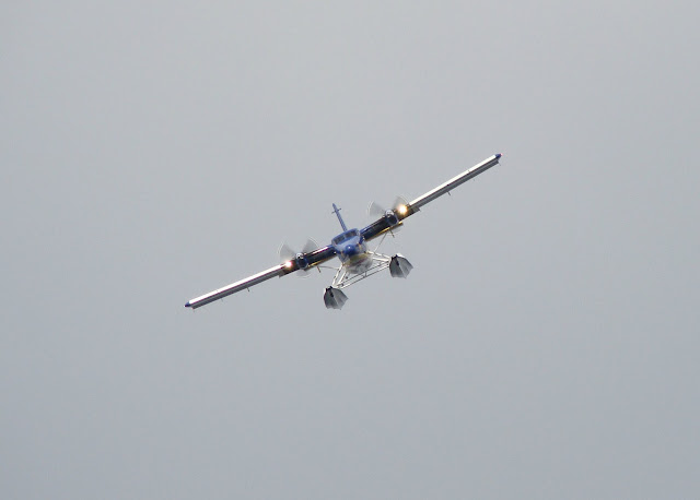
We spent the rest of the day setting up our camp and basked in the hot sun while we watched a Viking Air Twin Otter perform takeoff and landings right in front of our camp. The cool thing is that I actually made parts for that particular aircraft as it was sold to the Vietnam navy and their pilots were undergoing a rigorous training session on how to operate it in a float configuration. Throughout the weekend the Twin Otter came back a number of times in the various wind conditions that we experienced.

 |
| Just about to touchdown the Vietnam (Viking Air) Twin Otter lands in front of our camp. |
We did get a visit from an interesting character which turned out to be Ed (not Crazy Pete) who is one of the self proclaimed caretakers of Valdes Island. Ed lives just north of the beach area in a float house all year round and he has been in the area since around 1968. Later in the day I managed to gather enough dry wood from the beach and light our first kayak camping fire ever while Robyn made our customary first night dinner of shredded pork, rice and peas. Earlier in the afternoon we had talked to the ladies over in the meadow and invited them to come and join us at the fire were we sat around almost until 11:00pm as the twilight turned into a starry night.
 |
| Our first sunset at Blackberry Point. Pylades Island with the tiny Tree Island just off to the left. |
At around 1:00am I awoke to the distinctive sounds of two blow like rushes of air and as I lay there in my sleeping bag thought I could hear raindrops falling on our tent except .... it wasn't raining. I decided to get up and see what the sound was and when I walked down to the waters edge the absolutely flat windless ocean was alive with thousands upon thousands of fish jumping in the moonlight. My only thought was the blowing sound was a whale, porpoise or dolphin and the fish were being chased towards the beach. What a magical experience and no I wasn't dreaming :-)

2013 Paddle # 29 - Cedar to Blackberry Point
Friday was a down day as our group of kayakers arrived in various conditions of wind. Before they arrived Robyn and I did a little beachcombing towards Shingle Point in search of oysters. The Twin Otter returned almost like our own personal eye in the sky.
Unlike ourselves, most of our group made the direct crossing from Yellow Point or Ladysmith which normally would take about 1 hour. Of course the 10 to 15 knot SE winds had a bit to say in that as it added another 1/2 hour or so onto the crossing but everyone that was expected arrived safely.
Distance: 14.85 km (8.02 nm)
Friday was a down day as our group of kayakers arrived in various conditions of wind. Before they arrived Robyn and I did a little beachcombing towards Shingle Point in search of oysters. The Twin Otter returned almost like our own personal eye in the sky.
 |
| Single Point (IR) in the distance as Robyn searches for oysters |

Unlike ourselves, most of our group made the direct crossing from Yellow Point or Ladysmith which normally would take about 1 hour. Of course the 10 to 15 knot SE winds had a bit to say in that as it added another 1/2 hour or so onto the crossing but everyone that was expected arrived safely.
First to arrive was Yves and Patti followed by Peter and Hans about an hour later. Lynn chose a safer solo route from Cedar like we did but she got the full force of the SE head on all the way. Last to arrive was Joanne just before dusk after launching from Ladysmith.
 |
| Our little "town" of kayak campers tents starts to take shape. |
I think the group was pleased to see that we the "Rookies" had secured the primo camp spot so that made us feel good that we had contributed in a little way. Lots of laughs and stories were shared around the campfire that night as we planned for Saturdays paddle into Porlier Pass.
 |
| Pete in his tent and full size lumberjack axe. Yes, he brought it inside his kayak! |
Saturday morning we awoke to blustery conditions and so we decided to stand down for the day and not run through Porlier Pass. Tony and John arrived just before lunch and while they set up camp we (Yves, Patti, Hans, Jo, Lynn, Robyn and myself) set out to hike to the top of the cliffs that shadow the camp. Pete set a plan in motion to circumnavigate Valdes by heading through Porlier Pass and paddle up the east side of the island and return through Gabriola Passage.
On our way up the inner island logging road along came the one and only local Crazy Pete on his ATV and like a true caretaker he knew members of hiking party from previous visits. What a character as he called Hans the German and Yves "Frenchy" and talked about heading to Chemainus to pick up a new ATV. He gave us a few pointers on how to get to the look out on the cliff top and he roared off down the logging road on his ATV.
 |
| Crazy Pete heads off down the logging road |

After a break we started our way back to camp and found the old growth fir tree that Crazy Pete had told us about. He said it was 70 feet high but my guess was that it was much higher than that.
 |
| The hiking party and Crazy Pete's fir tree. |
Arriving back in camp it wasn't long before Aaron and Louise paddled in to complete our camp for the weekend. Robyn and I whipped up a batch of oysters pan fried with tabasco sauce and parmesan cheese for lunch. It wasn't long before Peter was spotted heading from Gabriola Passage about 1/2 hour earlier than anyone expected.
 |
| Yves took this picture of myself, Robyn, Hans, Jo, Pete, Lynn, Tony and Patti resting in the sun after lunch. |
 |
| Chef Patti and her oysters |
Sunday morning we awoke to breezy conditions but the forecast was for the winds to decrease so the group planned for a afternoon trip to see the Valdes cliffs up close. To pass the time away, Yves took a group of hikers to try and find the rumoured caves (and they found them) while Robyn, Lynn, Hans, John, Tony and myself hiked the logging road towards Porlier Pass looking for a vista viewpoint. After about an hour of hiking the girls spotted a clearing which gave us a view Yellow Point and the Mid Island Range.


Back at camp the group assembled on the beach for lunch and then we suited up for the paddle to the Valdes cliffs. Having never been to the cliffs before both Robyn and I were in awe of the sheer magnificence of what we were paddling next to. Pictures really don't do the rock formation justice in any way. It was simply stunning.

After visiting the cliffs Yves, Patti, myself, Peter and Aaron decided to make a run through Gabriola Passage and into Silva Bay as the current was nearing slack after the ebb. In the meantime Robyn, Lynn and Hans decided to head back to camp as we carried on. Gabriola Passage to me was surprisingly narrow but it was fun riding the back eddies and having to ferry across that last of the current. Arriving at Silva Bay brought back memories of last year when Robyn and I paddled the Flat Top Islands and it won't be long before we visit the area again as part of our "Haul In The Fall" trip
 |
| Patti, Aaron, Pete and Yves at Silva Bay |
Riding back through Gabriola Passage on the last of the ebb was more of an assisted push and very predictable. I am looking forward to bring Robyn through the passes in the fall as they can be navigated around the slack currents without any difficulty. After a brief rest stop on Valdes, Pete and I decided to head back to camp on our own while Patti, Yves and Aaron made it a lazy paddle back to camp. Arriving about an hour before sunset I must admit that after a hike in the morning and an almost 15 nm paddle I was sore and exhausted.

2013 Paddle # 30 - Blackberry Point to Silva Bay Return
Distance: 27.73 km (14.97 nm)
Monday morning we woke to overcast foggy conditions but with no wind. After spending 5 days and 4 nights at Blackberry Point we were sad to be leaving. After breakfast we started the dreaded dismantling of the camp and loading of the kayaks. At least it wasn't raining
Lynn decided to tag along with us on the paddle back to Cedar and by the time we were set to launch the fog had lifted. After saying our goodbyes with the rest of the campers it was time to let the flood currents assist us back towards Cedar.
But first we wanted to check out Whaleboat Island Marine Park to see if there was a landing area for kayaks. To our surprise and maybe not since nobody seemed to know about it, there wasn't any place to land a kayak. The island is simply a place for powerboats and sailboats to drop anchor for the evening.
On the way back we decided to stop for a rest at the white shell spit on the northern end of Ruxton Island. Although the tide was up there was still some landing area for us to get out and stretch our legs.
Back on the water we crossed Ruxton Passage and headed up the west side of DeCourcy Island where we could really feel the effects of the flood current pulling us towards Dodd Narrows. With a fully loaded kayak this was a really welcome assist from our friend the ocean. We landed back at Cedar and our vehicles were safe and sound just like we had left them.
What a fabulous weekend to try our first extended kayak camping trip. Our preparations for food and water paid off as the provisions made it through the weekend with a couple of days back up rations. We can't wait to do this again! Oh yeah ..... the shower was amazing once we got home!
Lynn decided to tag along with us on the paddle back to Cedar and by the time we were set to launch the fog had lifted. After saying our goodbyes with the rest of the campers it was time to let the flood currents assist us back towards Cedar.
 |
| Getting set to head out back to Cedar |
But first we wanted to check out Whaleboat Island Marine Park to see if there was a landing area for kayaks. To our surprise and maybe not since nobody seemed to know about it, there wasn't any place to land a kayak. The island is simply a place for powerboats and sailboats to drop anchor for the evening.
 |
| Whaleboat Island on the right with its step shores not accessible for kayakers. |
On the way back we decided to stop for a rest at the white shell spit on the northern end of Ruxton Island. Although the tide was up there was still some landing area for us to get out and stretch our legs.
 |
| Lynn and myself check out the "Mothership" looking boat from the white shell spit on Ruxton Island. |
 |
| Robyn's Delta Expedition 15.5 mini van of a kayak. Man they haul a tons of gear!! |
Back on the water we crossed Ruxton Passage and headed up the west side of DeCourcy Island where we could really feel the effects of the flood current pulling us towards Dodd Narrows. With a fully loaded kayak this was a really welcome assist from our friend the ocean. We landed back at Cedar and our vehicles were safe and sound just like we had left them.
What a fabulous weekend to try our first extended kayak camping trip. Our preparations for food and water paid off as the provisions made it through the weekend with a couple of days back up rations. We can't wait to do this again! Oh yeah ..... the shower was amazing once we got home!

2013 Paddle # 31 - Blackberry Point to Cedar
Distance: 13.68 km (7.38 nm)
YTD: 325.90 km (175.97 nm)
Love the photos and story! The raccoon on the shoreline is a particular thrill, especially as it seems your campsite wasn't troubled with them the way Bernie's was on Portland Island.
ReplyDeleteHi Paula, Thanks for taking the time to read about our latest adventure. We had been warned about raccoons at Blackberry Point but we never saw any around the campsite area. The only one we saw was a ways up the logging road when he was digging around looking for food. Portland Island.... I think I know the names of each one of them that lives there, LOL
DeleteI bought a boat from Crazy Pete in 1972.
ReplyDeleteGreat article.
Hi Dwight, Yes our first meeting with Crazy Pete and he sure is an interesting fellow. Nice to know that he cares so much about the island.
DeleteThanks for taking time to read my post.
Mark
Thanks for your post and photos, Mark. My partner and I are headed to Blackberry Point this weekend with Yves for our Paddle II course. Very excited!!
ReplyDeleteGood luck with your PC Level 2. Yves is a great instructor and Blackberry Point is a perfect location for a base camp for the course.
DeleteThanks for taking the time to read the post.
Mark
I find it very interesting that, whenever I go to Google a kayak camping destination, your blog pops up. THANKS for bloggin all of this Mark. :)
ReplyDelete