After our Saturday paddle of the Esquimalt Harbour we kinda thought it would be nice to take a day off on Sunday and just take it easy for once. It's been so long since we haven't been in the kayak on a Sunday and this Sunday wouldn't be any different. I woke early to the sun rising over Mt. Doug with brilliant blue skies and not a cloud to be seen anywhere.
Robyn was soon up and it didn't take long for us to make the decision to head back out to the Esquimalt Lagoon for a paddle to the Victoria Inner Harbour. Checking in on Facebook I posted our intentions and it wasn't long before Roy Scully decided to meet us for our 10:30 OTW departure. While waiting for Roy another kayaker arrived at the beach and he asked if we were waiting for Roy? After exchanging introductions, paddler Christian Gaujous would be joining our group for the trip.
CH-124 Sea King heads towards the Halifax Class frigate in the distance.
As Roy and Christian were preparing their kayaks, Robyn and I waited on the water and we watched a Canadian Forces CH-124 Sea King helicopter performing low high angle turns over the water about a mile from us. It then headed towards the Halifax Class frigate that left CFB Esquimalt just as we arrived at the beach. After circling the ship a few times it proceeded to land on the stern of the ship. The neat thing for me about seeing the Sea King conducting this exercise is that I see them take off from the 443 Maritime Helicopter Squadron at the Pat Bay Victoria airport while at work and wonder where they are headed. Now I know.
Is this really the last day of September??? Looks more like the middle of summer.
Roy paddling towards the Ogden Point Breakwater
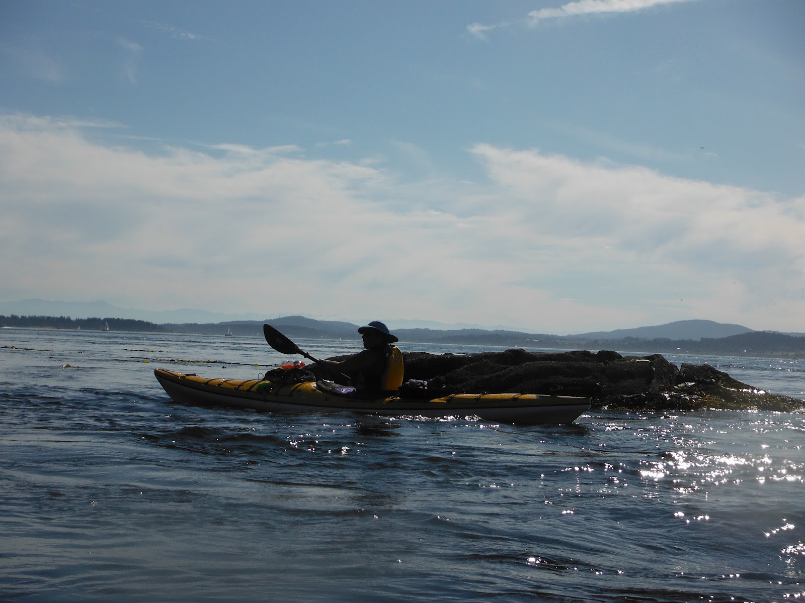
Following the shoreline, Roy and Christian played in the rock gardens as we made our way past Saxe and MacCauley Points and towards Ogden Point. Ogden Point is home to the Victoria cruise ship terminal but there were no ships in port today so we paddled along the breakwater and headed for the small beach just at the east end which would be our lunch stop. While I stayed behind and kept an eye on our kayaks, Robyn, Roy and Christian went to the Ogden Point Cafe to get some lunch that we ate in the glorious sunshine.
Robyn leading the way along the breakwater after our lunch stop
Once lunch was done with we headed back along the breakwater and into the Victoria Inner Harbour. Seeing the harbour while on foot is pretty neat but seeing it from a kayak is special.
There are so many places you can get to while on the water by kayak and Roy showed us a few of his favourites. The Victoria Clipper seemed to be one of the things that caught his attention so he got a real close up look at them. ;-). In fact there were two Clippers moored stern to stern which created an interesting tunnel feature. I won't say any more. LOL
We paddled around the harbour and checked out float plane docks. Every time I visit a float plane harbour I have to spend some time watching them take of and land. After all ..... I make parts for some of the De Havilland float planes being flown around the west coast. :-)
After leaving the harbour we headed on a direct route back to the put in location and stopped to play in some of the small surf waves. Unlike yesterday, the surf was pretty non existent but Roy did try his hand at surfing a small wave backwards. The video below will tell that tale. Another great day on the water to end the weekend and we wonder why we feel so tired on Monday mornings! LOL
It's been over a year of paddling and for some reason (maybe we were too busy LOL) we seemed to have missed kayaking out of the Esquimalt Lagoon. So this past weekend we figured we would saturate ourselves with a couple of trips launching from the great little sandy beach that is a) easy to access and b) doesn't cost a dime to park at. It doesn't get any better unless you are kayaking with great friends as we did both days.
Arial view of CFB Esquimalt and the harbour.
The Saturday paddle was planned during the middle of last week with Sheila and Neil joining us on a tour of the Esquimalt harbour which is home to the Royal Canadian Navy Maritime Forces Pacific (MARPAC). We had the opportunity to visit CFB Esquimalt only once before when the U.S. carrier Ronald Reagan (CVN 76) came to port for a visit. Otherwise we have only caught glimpses of it from higher vantage points around the city. So this paddle we would be viewing the base from the water.
Leaving the put in location we headed towards the Esquimalt Harbour but got side tracked by playing in the small surf waves just before Fisgard Lighthouse. It wasn't long before we were soaked but what the heck ... we are kayakers and kayakers get wet sometimes on purpose! After our play time we headed into the harbour and were greeted by a couple of Dall's porpoise hunting in the harbour.
Keeping our distance from the active navy docks we made our way to Cole Island which has quite a naval history dating back to the mid 1800's establish by the British. Once an ammunitions facility and now a heritage site, there is an effort under way to make the site a marine park to preserve the historical significance of the military presence on the west coast.
Sheila and Neil playing in the archways of the ammunitions buildings
We took the opportunity to land (literally) and check out the island and I have to admit it was pretty cool! It also gave us the opportunity to get the Geocache that is hidden on the island. We also met up again with a couple who were out on the their first paddle in their new Venture "Flex" kayaks and they stopped to explore Cole Island as well.
After our Cole Island exploration we paddled up the river under bridge near the 6 Mile Pub in hopes of reaching the waterfall. However the water level was too low but we did have some fun paddling in the shallows. Here Neil does the walk of shame after running aground in a narrow leg of the river. LOL
Heading back down stream we entered the harbour and made our way over to Richard's Island for our lunch stop. It also gave Robyn the opportunity to find the Geocache on this island as well. Robyn and I had a little opposite circumnavigation race around the island after lunch which you can see on our track at the 9km mark.
The idea was to see who could make it back to the starting point first. I will brag and say that I won but Robyn held her own and I only beat her by about 15 yards. I knew she would love that Werner paddle!!
We had dinner plans for later in the day so we had to be off the water around 3:30 so we paddled back past the lighthouse and played in the wave surge in the rock gardens. Oh yeah .... I tried my skill at towing the other three paddlers while they hung onto my kayak. Yeah ...... I don't want to do that too often. LOL
Nearing the put in location we again saw small breaking waves near the point so Sheila and I headed over to them to try our luck at surfing the small sets. Although tough to see the waves starting to form, every so often a set would show themselves a little further out and we tried to ride them.
This was my first real experience of surfing waves breaking on a beach and I must admit that I am pretty well hooked and want to do it again and in bigger conditions. It wasn't long before Robyn and Neil were right in the surf zone riding the edges of the waves as they came in. Another great paddling extended summer day on the west coast.
Earlier this spring while staying at the Living Forest RV Campground (one of our favourites) we planned to return in the fall with Dave and Kelly Reaville by checking the tides of the Nanaimo River estuary for optimum water / paddling conditions. Selecting this weekend, the tides were perfect with most of the estuary covered by water all day allowing us to leave the river at the put in location without worrying about getting back later in the day.
To start the weekend we spent Saturday hiking / Geocaching around Newcastle Island and then went for lunch at the Dinghy Dock Pub. The last time we were at the Dinghy Dock we arrived by kayak but this time we took the little walk-on Nanaimo Harbour Ferry. Hiking around Newcastle was the perfect way to check out the facilities of the Provincial Marine Park that we no doubt will use during a future kayak / camping trip.
Hip "Fit Kit" installed
Sunday morning we woke up to a slightly foggy morning with low clouds which the sun was working hard to break through. Over the past 36 hours there has been a noticeable change in the daily temperatures and right on target since Fall officially arrived at 07:49 in the morning. Our plan for the day was for Dave and Kelly to rent kayaks from the campground and then we would venture out across the estuary and follow the shoreline over to Duke Point. It would also be a good opportunity for us to try the Delta Fit Kits that I installed in our kayaks last week as well as our new GoPro Hero 2 Dive Housing.
Dave & Kelly's Necky's at the Living Forest Campground beach on the Nanaimo River
The campground has a fleet of Necky Rapid's which were perfect for Dave & Kelly. They have been on secluded day trips before with us and we enjoy taking them out with us to experience our kayak adventures. The conditions were absolutely perfect with no wind allowing the group to easily see the shallow bottom of the estuary. A few curious seals played around us as we made our way over to Duke Point but they never ventured close enough to see them under water. Robyn took the lead as she had the GPS with Geocaches loaded in hopes that we would be able to find some close to the shoreline. Sure enough the first one we came across was pretty neat.
Duke Point Petroglyph .... two headed wolf or dogs??
Although we are pretty sure this is not an ancient petroglyph, it was great to see from the water and only a few steps away from the high water line. This was also our first Geocache stop as it was hidden close by.
Continuing our paddle to the north we explored some of the rock gardens which Dave seemed to like to play in. Our next goal was to visit an Earthcache that was located further along the shoreline. Unlike a Geocache, an Earthcache doesn't have a hidden object but rather it brings you to a geological formation and teaches how it was formed. In this case the Earthcache was a honeycomb formation in the sandstone and to complete the challenge we needed to get information off the little bench just above on the trail.
I scrambled out of my kayak to get the information and took a picture of the Earthcache and our paddlers just below.
One thing that we didn't know about the west side of Duke Point was the amazing sandstone galleries that can only be seen from the water. We have hiked the trail along the shoreline but unless you are on the water you miss some pretty cool formations.
Having seen these types of formations before it was great to share a bit of what we do when kayaking with Dave and Kelly. This was a perfect example of why we kayak and how such and experience like this just increases our passion for being on the water.
Lunch stop
We stopped for lunch in a little cove which also had a Geocache and Dave & Kelly made their first kayak up to find. Geocaches are great to find while out for a walk or hike but they are special when you arrive by kayak.
Heading back to the campground along the shoreline the north winds started to pick up a bit. Both Dave and Kelly did great in their little kayaks and there was a hint by Dave that maybe ..... just maybe they should get a couple little kayaks. Living so close to the Brentwood Bay ferry dock we think it would be a great idea!!
The RV's from the Nanaimo River
The tide was just starting to ebb as we entered the the Nanaimo River and paddled our way back to the campground. It was now my turn to try and complete a roll in my Delta Expedition 15.5 for the first time so we found a spot on the river bank that was shallow enough to try and get 'er done. I have recently completed rolls in kayaks owned by our kayak instructors but had yet to pull one off in my Delta. So under the watchful eyes of the group I said to myself " I hope I don't screw this up" as how embarrassing would it be for Kayak Man to "head fail". LOL I also decided to use a paddle float (thanks Sheila) for orientating my paddle power face correctly while inverted.
The rest is history .... 7 out of 7 rolls completed successfully with each one feeling a little bit better than the previous one. The best part was capturing it on video with my bow mounted GoPro Hero 2 as well as Kelly and Robyn getting other perspectives of the same rolls.
GoPro Hero 2 video
Kelly's video of roll #1
Another great day on the water shared with some good friends. With the ever increasing shorter days and cooler temperatures its time to start thinking about Fall kayaking opportunities. A year ago we just wanted to get out in calm conditions and start this amazing adventure. Now we are looking at the play zones for this Fall. Anyone want to come out and play with us?? ;-)
During our Rum Island excursion the previous day with Sheila and Neil we talked about heading to Thetis Lake on Sunday to spend the afternoon exploring the network of little lakes. It would also give us the opportunity to play a bit and the end of the paddle. ;-) Although Robyn and I have participated in a couple of rolling sessions recently at the lake we have never spent the day just meandering through all the nooks and crannies.
So we met up with "the kids" just after lunch and headed out for an extremely Sunday lazy day paddle which was quite a change for us. Typically we stick to the ocean adjusting our paddling agenda depending on what Mother Nature has in store for the day. Being on a lake for a paddle (our first was almost a year ago) the absence of currents and wind blown waves was quite refreshing as it allowed us just to take in the warm sun and unwind a bit.
We searched the blown down trees and stumps and found a few turtles, herons and even a river otter who didn't seem to mind us as he crunched on something (maybe a frog) for lunch. For the most part it was just a Zip-a-Dee-Doo-Dah type of day. :-)
Heading back to our put in location at the main beach it was time to play a little bit with our rolling techniques. Sheila made it look so easy as she effortlessly did them from her strong side, off side and re-entry rolls as well. She even tried everyone else's kayak along the way to reinforce that our Delta's would roll too.
After a couple attempts in my Delta the seat back had a minor (fail) so I jumped into Sheila's Atlantis and went to work while Robyn worked with Sheila on some bracing skills. It was a pretty good afternoon of practice and I managed to complete several rolls (with paddle float assistance) and also had a number of "head" fails as well. For the non kayak readers out there, the "head" fail is when you let your head move past the centre of gravity before the rest of your body has come out of the water. The result is that you end up back in the water really quick and when you reach the surface again your hear "HEAD" from the peanut gallery. LOL
Robyn did manage to capture one of my successful rolls on video as well as many of my "head" fails. Above is one of the good ones while I was in Sheila's Atlantis. Sheila also completes a re-entry roll in my Delta. It was good to leave the water on a positive note and in future I just gotta keep my head down and get 'er done!!
Summer continues strong here on the west coast with warm days and amazingly calm winds it made for the perfect opportunity to explore some of the furthest southern Gulf Islands from Sidney. Today we teamed up with Sheila and Neil for a day paddle to Rum Island.
But first a little history about our destination is in order since it it has played a role in the relationships between Canada and our U.S. friends just across the Salish Sea. Rum Island otherwise known as Isle-de-Lis, is located less than a mile from the Canada/U.S. border. Just like its name implies it was used as a base during the 1920's prohibition era from which smugglers used to transport prohibited spirits to Stuart Island in the U.S. The island became part of the Gulf Islands National Park Reserve in 1978 and although there is very little evidence left of the smugglers dwellings it has become one of the favourite camping destinations for kayakers on the south coast.
Playing with my Fuji camera before launching, I discovered the panoramic feature. In the distance
Little Shell and Ker Island can be seen almost 2 kilometres away which we would visit on the way back.
(see track image 19km point at end of blog)
Launching from Ardwell Beach, the conditions were absolutely perfect for this day trip to Rum Island. Taking advantage of the conditions we set out for a direct 5 km crossing to Forrest Island where we met up with the SISKA group (4 km mark) heading to Sidney Spit for the annual beach clean up. Lead by Mike Jackson the group was checking out the Little Group of islands before heading to work on Sidney Spit.
Almost at Forrest Island we kept an eye open for the Anacortes ferry coming around Sidney Spit.
Paddling along Gooch Island. Almost to
Rum Island just around the corner
We paddled the length of Forrest Island and then made the 2 km crossing to Gooch Island and finally to our destination of Rum Island. The great thing about the perfect conditions is that it allowed us to relax, chat and eat wine gums along the way. At least Sheila and I did :-)
This was our first time visiting this little island and it has now been added to our kayak camping bucket list. With only 3 established tent pads facing south east the view is spectacular and today we were surprised to see them all full of boaters camping gear as evident by the giant Rubbermaid gear tubs. Nobody was around camp so we borrowed a pick-nick table for our lunch break.
After lunch we hiked around the island on the not too established trail and I think we all got a little Salal bush whacks along the way. Oh yeah .... If you take the lead on a hike such as this make sure to carry a stick to knock down all the spider webs. I didn't and I'm pretty sure I had a bunch of those critters that I hate crawling all over me. LOL The hike allowed us to check out some of the other places that you could set up camp if the main area was full and offered some great views as well.
Stuart Island just beyond the arbutus tree. Not far to head to head to the U.S. from this location by kayak.
The kids ... Sheila and Neil
The tombolo landing area between Rum and Gooch Islands.
It was time to head back and this is when Sheila turned the paddle over to me. What???? I was just along for the paddle today and left all the planning to the girls for this trip. OK ..... time for me to play guide. So .... I, yes I, navigated, no GUIDED the group back home on a slightly different course island hopping our way to the north past Comet and Brethour Islands and then through the tiny pass between Sheep and Domville Islands.
Making sure the group was together, we stopped for a brief liquid break and for those who might feel energized to actually try and go to the bathroom I even took them to the local outhouse. No kidding, this was an actual functioning outhouse that is on the west side of Sheep Island. Too funny!!
Robyn playing in the currents near Dock Island
GUIDING the group over to Dock Island we played in the flood currents a bit before we made our way back to our put in location. It was a good way to unwind a bit and build up an appetite for our next port of call ... Rum Runners Pub in Sidney. Kinda fitting I would say ;-)
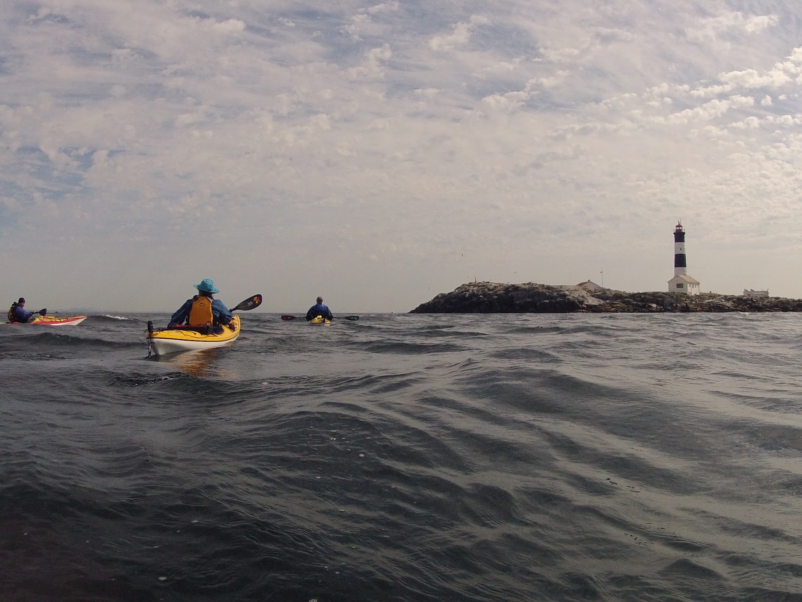
It really is quite amazing thinking back to a year ago when we were only dreaming of paddling out to the Race Rocks Ecological Reserve. Yesterday that dream came true as we headed out to the landmark that can be seen from almost anywhere while on the water around Greater Victoria. For kayakers planning excursions around the south coast, Race Rocks is also a primary current station that is used to determine the amount of current that can be expected while on the water. With currents ebbing and flowing around 7 knots at various times of the year, Race Rocks offers lots of opportunities and conditions to visit the group of islands depending on your skill level. The last quarter moon was upon us and the maximum ebb current for our paddle only reached -2.3 knots with pretty lazy tides for the day.
Race Rocks Lighthouse in the distance
Our good kayaking friends (Sheila & Neil) decided to join us on the paddle so we launched out of our base camp at Pedder Bay RV Resort around 10:00am. Checking the marine forecast we had a good window of opportunity to make the trip before the westerly winds picked up later in the day (and boy did they). With a slack tide around noon we made our way past the DND dock, Bentinck Island and made the crossing out to Race Rocks in a slight chop. The slight westerly breeze also allowed us to hear the noisy sea lions before we got sight of the lighthouse on the way out of Pedder Bay.
There were lots of whale watching boats in the area and I was getting excited about possibly seeing a killer whale for the first time by kayak. In fact at one point as we got closer to the small western islets I spotted a couple of black objects (dorsal fins?) moving across the surface of the water about a mile from us. The objects moved behind a small islet and as our distance to them reduced our excitement increased until ...... the objects appeared from behind the islet and then I realized that they were a couple of kayakers! RATS!!!!
Approaching the lighthouse from the west we played in the increasing rip tide and started
taking pictures of the sea lions that were sunning themselves on the rocky islets.
Keeping a close eye on the approaching cold front we worked our way through the islets and in view of the massive Steller and California sea lions. We were totally surprised at the number and the size of some of the bull Steller Sea Lions and they were just as curious about us. Keeping our distance not to cause them to seek protection of the water, they let us pass by without displaying any aggressive signs. The pictures don't really do their size justice but in the picture below you can see a seagull in relation to the Steller Sea Lions. We were quite happy they stayed were they were.
Many of the smaller California Sea Lions were playing in the water around us and they seemed to like the developing rip tide that we had just paddled through. Somewhat like a seal they seemed more interested in playing with each other than bothering us. Only the occasional Steller Sea Lion approached making a big splash before heading away from us.
Not worrying about the lighthouse keepers, the sea lions camp out in their back yard behind the house. One of the keepers was busily working around some of the buildings and the sea lions didn't pay much attention to him. I guess over time they get to know each other and coexist but one has to wonder how the keepers put up with the constant barking of the sea lions.
One last picture opportunity before heading back to the islets around Bentinck Island for lunch. As expected those westerly winds started coming up pretty good which made the crossing back a little chunky until we got into the wind shadow of Beachy Head.
After a well deserved lunch we played in some of the rock gardens heading back into Pedder Bay. Seeing the abandoned half submerged floating dock Sheila and I decided to see if we could "seal" our way up on top of it. Shelia showed her pro form even though there was a slight creaking of composite from her kayak. Me on the other hand did pretty well everything wrong and it's a wonder how I didn't end up rolling off the dock.
Back at camp we fired up the BBQ and celebrated with Sheila and Neil until the sun started to set in the windy west. Another great day on the water and the start of our second year of kayaking. If the second year is anything like the first year it should be a great experience and we look forward to sharing it with our readers.
Our kayaking adventure began 365 days ago when we rented a couple of kayaks at the Pedder Bay RV Resort and the rest is history or should we say documented in our blog. This weekend we are returning (site #59) to where it all began, but this time we have our own trusty rides that have taken us on 60 individual adventures. That first upside down wrong way paddle stroke in the rentals will forever be remembered along with how hard we fell in love with this amazing pastime. We didn't have a clue what we were doing that first day on the water but since then so many people have been instrumental in our growth and passion to be on the water.
First off a big thanks to the folks at Ocean River Sports who have provided excellent guidance and customer service in outfitting us with our Delta kayaks and gear. Special thanks to Gary Doran, Gary Allen and Janette Galan who took a couple of newbies under their wings and started our skill set development.
This past January we made contact with SISKA President Sheila Porteous and went to our first club meeting where many friendships started to develop along the way through group paddles or club endorsed events. Sheila became our mentor and patiently offered insight, constructive advice and encouraged us to continuously build our skills and have fun doing it. In other words ...... Get 'Er Done!!! Thanks coach!!!
Yves Aquin of Go Kayak has refined some of our existing skills and helped us learn new ones while building our confidence to handle different water conditions that we have come across recently. Thank you Yves for trying to polish a couple of diamonds in the rough so to speak.
To all our new paddling friends that we have met along the way ....... you have all made the adventure so special and we thank you for being part of it. Many of you we have only met through our blog or blogs we are following or just on Facebook the kayaking social media site (LOL). We look forward to actually meeting you in person one day to share stories over our favourite beverage. To all of our existing friends and family, thank you for following our our adventure this past 365 days. But be warned ....... there are more adventures to come so if you wonder what we are up to just keep coming back to Gecko Paddler.
This past Labour Day long weekend Robyn and I headed out on another kayak camping expedition and we decided to check out Prevost Island National Park Reserve. Our original plans were to paddle to Portland Island and then up to Prevost Island the following day but thinking about this a couple of times we decided that might be a bit of an ambitious plan. It's not that we couldn't do the trip in terms of distance but more because "what if" the weather turned ugly? So keeping things in perspective of why we were going in the first place (R&R) we decided to take the first BC Ferry on Saturday morning over to Fulford Harbour (Salt Spring Island) and drive up to our planned put in location at Ganges.
With the long weekend upon us and a targeted ebb slack tide that we wanted to be on the water by, we woke up 04:30 hours early on Saturday and headed for the ferry terminal to make sure we could get on the 07:30 sailing. It figured ..... no vehicle traffic to speak of and we were in Fulford Harbour by 08:00 and then it was only a short 15 minute drive through the sleepy Salt Spring countryside to Ganges. The only activity around were the local merchants setting up for the Saturday morning Ganges market.
We checked out a few possible launch locations in town and then headed to where Salt Spring Island Adventure Tours are located to check out their kayak launch facilities. Robyn had been in touch with them earlier in the week and we had permission to use their dock if needed but parking was going to be an issue. Feeling a little hungry we headed across the street to the Harbour House Hotel for breakfast and afterwards we inquired about parking in their lot over the weekend. The food and folks at the hotel were amazing and we were granted permission to leave the truck in their parking lot while we were out on the water. You have to love the small island hospitality!!
Launching next to Moby's Pub
We decided to launch from a small private drive down boat ramp ($6.00) right next to Moby's Pub to save hauling gear and boats down onto the docks. The pub would come in handy but more on that later. :-)
When we arrived and started to load the kayaks the water was absolutely flat but by the time we headed out we noticed a SE breeze starting to ripple the water which in turn was blowing straight into our faces. For this trip we planned to use our new Kokatat dry suits on the advise of coach Sheila and they sure came in handy.
Chocolate Beach, Third Sister Island
We left Ganges at 10:30 and the plan was to reach Captain's Passage by 12:00 to take advantage of the slack right after the ebb tide for the crossing. This was plenty of time to explore some of the islands in Ganges Harbour and in particular stop at Chocolate Beach located on Third Sister Island. We had heard about the beautiful little beach and the gnome like outhouse there and neither disappointed us.
Now comes the interesting part of the outward bound leg of the trip to Prevost Island. Right up to the evening before the forecast was for light winds and then 10 to 15 knots coming from the SE later in the afternoon. But we kayakers know one thing and that is the winds can change so suddenly and sure enough those 10 to 15 knot SE winds came up big time as we left Chocolate Beach. This meant that we would be making a number of "Go, No Go" decisions as we made our way first to Welbury Point and then over to Scott Point which is at the entrance of Long Harbour. During this time the water grew darker and white caps were starting to break over the front of our kayaks and yes the dry suits kept us from getting drenched. Both Robyn and I were very comfortable in the conditions that we were paddling in and at no time did we feel that things were starting to get out of hand.
We were hugging the shoreline as we crossed the entrance to Long Harbour assessing the winds again and also getting our first look at Captain's Passage from Nose Point. As I expected, Prevost Island did provide a little relief from the SE winds and waves but now our next task was to cross Captain's Passage while all the mega yachts and sailboats were ripping through the narrow 1/2 mile channel. I really should have put my GoPro on my helmet at Chocolate Beach because it would have been neat to get capture some video of the sea conditions and the pleasure craft that we had to dodge through the passage. I must admit that the bigger boats did take care to avoid us although there were a few times that we were bobbing through 5 foot chop!
Our arrival at the Prevost Island Marine Park camp
The last real hurdle of the crossing was going through the tide rip at the tip of Selby Point as we entered James Bay at Prevost Island. Here we did a little "surfing" and as Robyn said later .... "That was kinda fun". It wasn't long ago that we paddled Baynes Channel in 4 knots of ebb and Robyn felt a little uneasy in those conditions. Now here we were taking on the toughest conditions we have ever been in and we both handled it extremely well. I was so proud of Robyn's skills today (and all weekend) and making it to our Prevost Island Marine Park camping destination was a well deserved reward.
Tree #14 camp
Our camp for the weekend was nestled in an old orchard and we simply had to find a location to set up our tent and call it home. Picking tree #14 we set up camp and celebrated with a couple of glasses of wine and made a hearty lunch before settling into reading our books for the rest of the day. Bed time came really early after a long day as we climbed into our sleeping bags just after 8:00 with the intent to doing some more reading until dark. That didn't last long as before we knew it we were fast asleep and didn't hear a thing until waking up just after 7:00 the next morning.
The outward bound route from Ganges to Prevost Island
Sunday morning we woke to another beautiful day with winds forecasted to come from the SE again but not as strong as the previous day. We decided to explore the western side of the island for the day and set out with the ebb tide in our dry suits to check out some of the inlets, coves and islets on our way to the south east marine park at Portlock Point.
Here we stopped for lunch and were able to connect to the internet to let our family and friends know that we were safely on the island and enjoying ourselves. One of the coolest sights was seeing a Spirit Class BC Ferry coming roaring around the corner out of Active Pass towards us.
Making our way back to camp we were pushed along with the flood tide and SE breeze and then it really became apparent that wearing the dry suits in warmer weather increases the dehydration issue. I sure felt the effects of overheating the last couple of kilometres and once back at camp I wasn't feeling too great at all. It was a good thing that we brought extra water as I needed it to help me get hydrated again. An important lesson learned.
Sunset from our camp beach
Just as we were making dinner a young couple arrived by kayak and talking to them we found that they had paddled from Portland Island (our original plan) and had just started a nine day tour of the Gulf Islands starting from the Anacortes ferry terminal in Sidney. After dinner we talked with them a bit more and found that they are from Oregon (Portland & Eugene) and once a year they do a big trip like this. Their favourite place to paddle??? The Gulf Islands!!
Exploring Prevost Island
Mom and baby deer right outside our tent
Monday morning we woke early (06:ish) to the departing Jazz Dash 8 heading to Vancouver and then the Salt Spring Island Air Beavers taking off out of Ganges. Time to get the day started so we made some hot chocolate and watched the sun rise in the camp. Checking the VHF radio the forecast was for NW winds 15 to 20 knots increasing to 25 late in the afternoon and watching the water in James Bay starting to change from a ripple to a slight chop it was decision time. Do we go now or wait it out to see what happens???
We decided to "bug out" and by the time we were on the water just before 10:00 the white caps at the entrance to the bay were forming pretty good. Add in the factor that we were right in the peak of the ebb tide, the crossing of the rip at Selby Point was entertaining :-) By using the ebb flow we allowed it to carry us over to Nose Point and across Long Harbour towards Ganges Harbour. Unlike our crossing on Saturday morning there was very little pleasure craft traffic so that was comforting. Once we made our way back to Welbury Point we were protected from the NW winds and for the most part the paddle back to our put in location was really relaxing. One thing we did notice were all the homes that we couldn't look at on the way out due to the water conditions we experienced. Some pretty amazing homes on the shores of Salt Spring Island.
Remember Moby's Pub?? Well after loading up the truck we decided to celebrate with a cold glass of Salt Spring Island Ale and probably one of the best home made burgers we have ever had. A great way to finish off a trip where we were able to use our kayaking and camping skills to the fullest extent. Ya ..... I think we did good!!!


.bmp)