Wednesday, November 27, 2013

Discovering Discovery On A Winter's Day

After a busy week of playing with our favorite stuffed animal (Santa Bear) we managed to take a day off and head out on a paddle on Sunday to Discovery Island. Located only a very short distance from 10 Mile Point the Chatham / Discovery Islands are an amazing place to kayak to but transiting Baynes Channel can be a challenge for even experienced kayakers.

The key to enjoying a relaxed paddle to the islands is checking the currents and wind forecast as together they can present some formidable conditions. It was almost perfect with just a gentle ebb and 5-15 variable winds from the north. Now it's time to be embarrassed ......  I just realized by checking my data for the blog as well as the track of our paddle that I had used the 2014 Current Table! By the 2014 table, Sunday was (or will be) a predicted a slack at 12:44 and then a gentle flood reaching a maximum of 1.2 knots at 14:24. In fact using the 2013 Current Table the slack was at 09:09 and then it turned to the ebb with the maximum flow reaching 3 knots at 12:40. Now I know why we got such a good push down the east side of the islands ....DOH!!

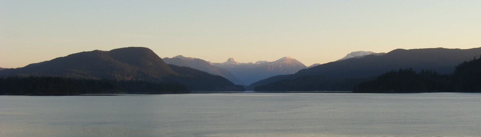
Mt. Baker comes into view past 10 Mile Point. We even saw a glimpse of Mt. Rainier south of Seattle.

Launching out of Cadboro Bay around 11:30 we headed out towards Jemmy Jones Island and then across Baynes Channel towards the radio towers. Our route would take us south down the east side of the islands towards Rudlin Bay where we would have lunch at the Discovery Island Marine Provincial Park. Adding to my confusion about the currents I wondered why there was a pretty good flow between Strongtide and Vantreight Islands but even so it allowed us to practice our ferrying skills to reach Chatham Island.

Paddling past Puget Cove we rode the ebb current past Griffin Island towards the old boathouse keeping an eye out for the wolf that is now a resident of the islands. There were lots of seals on the islets today so we gave them a wide berth but they still entered the water and came to see what we were up to.

Robyn paddles past Alpha Island with Mt. Baker in the background

As we were passing Sea Bird Point (Discovery Lighthouse) our speed really started to pick up with hardly any paddle strokes needed. Looking at our track we were being carried along in the currents close to 6 knots which really made me start thinking about my current calculations for the paddle. Passing the lighthouse I also thought I could hear voices but couldn't see anyone until we landed on the beach in Rudlin Bay.


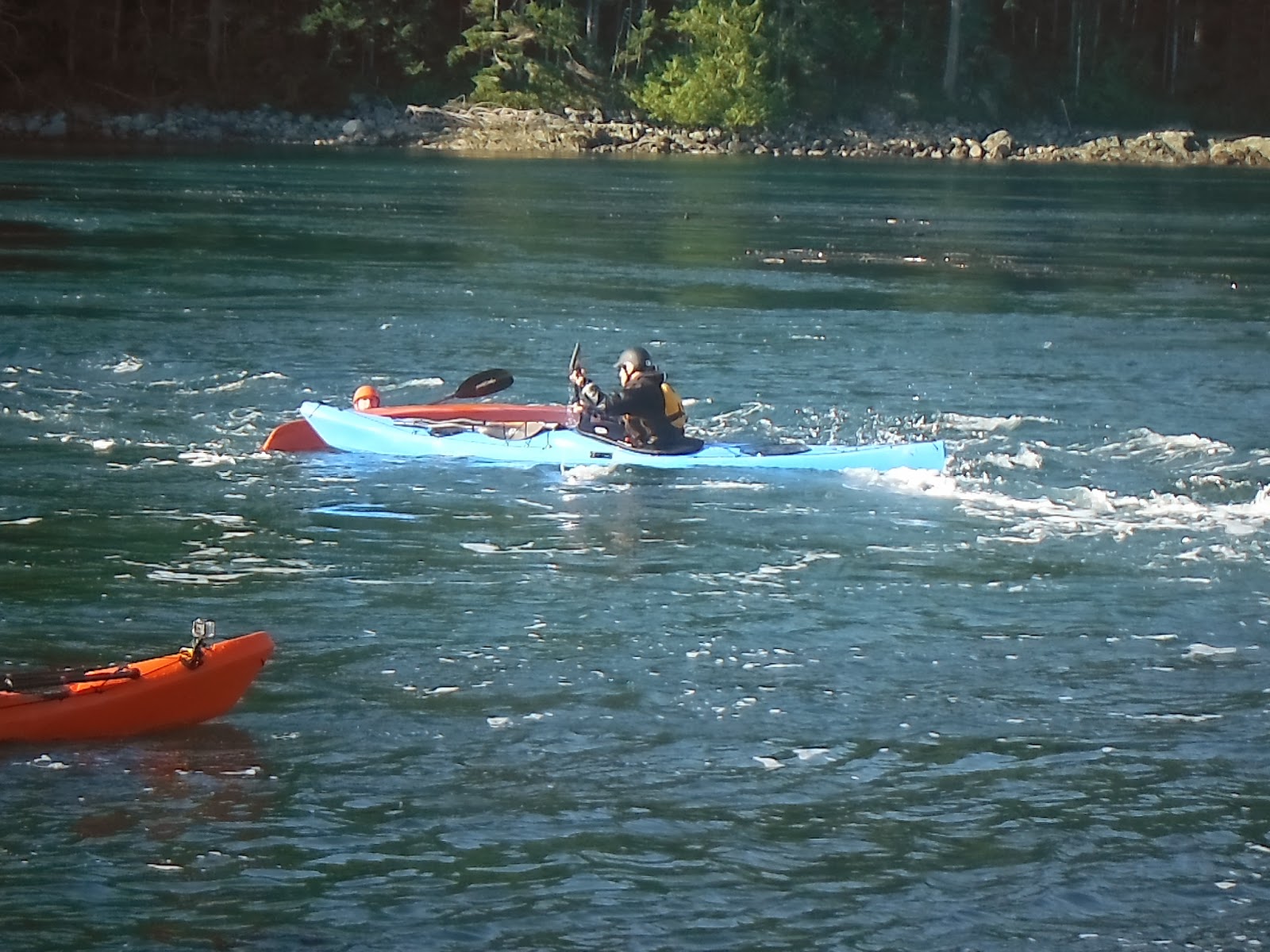
Michael, myself and Scott discuss some of the features of our kayak mini-vans (Delta 15.5 Expeditions)

Sure enough a couple of kayakers were following us and it turned out to be Michael and Scott who are fellow SISKA members. We all headed up to the picnic tables and had lunch in the warm sunshine and it was hard to believe that it is the middle of November. Did anyone bring a tent??? LOL

From L to R: Michael, Robyn and Scott


While the boys talked "kayak", Robyn did a little exploring of the camping area. It was nice to see that the park has added a few upgrades with the new picnic tables and food caches but there was no sign of the wolf.

The other day I was chatting with Mario via Facebook whom I met at Surge Narrows a few weeks back and he mentioned that he saw the wolf last Wednesday.  You can read Mario's wolf encounter on his blog at  http://mstoc.co/journal.html . So she still is around for those lucky ones who manage spot her. She is still on our kayak bucket list.


After lunch it was time to head out and explore the shoreline in hopes of getting view of  "Staqeya" the wolf but she was nowhere to be seen. Maybe another time.


With the sun starting to get lower on the horizon it was time to head back towards our launch location. Discovery Island is one of our favorite places to visit especially in the winter months and the picture below tells it all.


Making our way along Plumper Passage we came across Mike and Dan who were heading around the islands in the opposite direction. Mike probably has the record for paddling around the Discovery / Chatham Islands by kayak as he lives only a couple hundred feet from Cadboro Bay. Mike's blog can be read at  http://mhjpaddling.blogspot.ca/

Arriving back at the beach I was really confused as the tide was now visibly further out so I knew something wasn't right about my data that I had used for the paddle. Although we had no issues during our paddle it just goes to show you to check and double check your paddle float plan before heading out. It was still a great day to be out on the water even if I had no idea what was happening!


2013 Paddle #71 Winter of Discovery 
Distance:  8.47 nm (15.69 km)
YTD: 400.9 nm (760.87 km)


Monday, November 11, 2013

Weir's Beach Cachin'

We spent the Remembrance Day long weekend at Weir's Beach RV Resort to just unwind a bit..... once we finally got settled for the second time. There's nothing like a trip back home on a Friday evening in rush hour to pick up the TV / Shaw controller that we forgot. :-) LOL

No tent for us this weekend! 

Other than heading out on a coastline paddle we just hung around the camp and went for a walk over to the Lester B Pearson College of The Pacific to do a little scouting for the 2014 Pacific Paddling Symposium. On the way we also did a little Geocaching by land and I used the time to write the blog entries from our Surge Narrows experience.

Robyn with another successful Geocache find by water

On Sunday we headed out for a paddle towards Albert Head catching the last of the flood on the outbound leg and riding the ebb with the increasing SE wind pushing us back to camp. Along the way we located a water accessible Geocache on the beach and then headed towards Witty's Lagoon where we spotted a naked man cleaning up driftwood (sorry no pictures as this is a family friendly blog) LOL. For the life of us we couldn't figure out why a naked dude would be out in the cold wind with a hint of showers in the middle of November!

Robyn has a chuckle seeing the nude dude, me..... it's more like OMG!!

But then I saw the sign spray painted in yellow <<< NAKED <<<< on a log pointing towards his location.
Seems that we stumbled across one of Victoria's Clothing Optional beaches. OK, I can appreciate (those of you who know me don't laugh) the fact that nude beaches exist but holy cow what was the guy thinking of doing it in November??? You know what happens when it's cold out?? Enough of that short story. :-)

Near Witty's Beach Robyn tried to locate another Geocache but kept getting interrupted by "mugglers" (people close by) who were heading towards the yellow sign. What the heck were they thinking??? It's November for heavens sake!!

While Robyn was doing her best to find the Geocache, I did a little surfing on the rollers running across the sand bar at the entrance to the lagoon. It was great to use some of the surf skills that I learned while we were at Surge Narrows.


We also did a little exploring of the rocky shoreline and noticed that there were lots of sandpiper looking birds that we hadn't noticed before. It turns out that they were Rock Sandpipers whose migration route brings them to the south coast for the winter all the way from their summer range of northern Alaska. I think it is pretty amazing that they travel so far and back again.

The Rock Sandpipers didn't seem to not mind us at all.

With the current starting to ebb we rode a back eddy all the way to Albert Head and got a look of the City of Victoria before making the turn to head back to camp. On the way we stopped at the Twin Islands to stretch our legs where I performed the perfect wet exit out of my kayak in less than 1 foot of water! Robyn heard the commotion behind her but better yet the GoPro captured it.

Graceful huh?


After a quick stretch and a laugh we then made a direct route for camp as the wind was starting to pick up. With the wind and current coming directly from behind us we spent a lot of energy just keeping our kayaks on course surfing on the waves. Of course it was nice gong back to the warm RV though :-)


2013 Paddle #70 Geocaching By Water 
Distance:  7.93 nm (14.68 km)
YTD:  392.43 nm (745.18 km)

Sunday, November 3, 2013

Surge Narrows Expeditions - Day #3

Sunday ...the last day at the lodge and it was a play day for the paddlers to do as they wish before heading home. Robyn and I decided the night before that we would join the group heading back up to Surge Narrows to play in the currents and on the wave while others worked on rolling skills or just went for a leisurely paddle.

The time changed back to Pacific Standard Time overnight which meant that we had an extra hour of sleep before getting up to prepare for a long day of paddling and the trip home. It also meant that it was getting lighter in the morning and today was stunningly clear when I started taking pictures of the sunrise from the deck.

One of my favorites. The sun just starting to appear on the summit of Mount Doogie Dowler

A panoramic view L to R of Sturt and Goepel Islands, Whiterock Passage and Read Island

Our group was on the water at 09:30 and we paddled up to the narrows in the brilliant clear blue skies and warm sunshine. Since this was not going to be a clinic format, the paddlers needed to look after each other when we arrived at the narrows.

Huw reminds us to use a buddy system before heading into the narrows. Nobody paddles alone in there. 

On Friday I didn't really notice the slack between the ebb and flood but that might have just been the excitement of being at the famous Surge Narrows for the first time. Today I tried to see if there truly was a period of slack and from my perspective the water was always moving around the islets. There simply wasn't a slack time in my opinion.

As the current started to build Robyn decided that she would take some pictures and video from the small landing area just feet away from where the main wave develops. I'm glad that she did!

The wave just starting to form on the left and Robyn has a front row seat to the action on the right.

Robyn's little islet was the perfect platform to see our group as well as a couple of campers who spent the night on Peck Island.

L to R: Ryan, Kevin, Jennifer, Huw, Will and a couple of kayakers on Peck Island

Robyn also found the remains of lots of large sea urchins that had been consumed probably by river otters, eagle etc.  This one measured almost 6" across and was very fragile having dried out in the sun.


At the wave our group took turns working in and out of the back eddy into the main flow. My main goal for the day was to keep my paddle engaged in the water to provide bracing when I needed it. Coming off the wave I noticed the two kayakers (one in a blue Delphin) who were camping on Peck Island had joined us on the water.


As I paddled up next to the Delphin the kayaker said "You're Mark aren't you? I know you from Facebook" Talk about a the power of social media! Mario introduced himself and Reuben who was on the rocks talking Robyn. One thing lead to another and I mentioned the orcas that our group saw heading towards Surge Narrows on Saturday. Mario explained that they had a close up encounter with one of the orca only feet away the evening before.

Kaikash (A46), a 31 year old Northern Resident  Orca


Absolutely amazing!!! Now you know why our passion for kayaking is as intense as it is. You can check out Mario's blog at http://mstoc.co/journal.html for his story of the orca encounter. Thanks Mario for sharing your pictures and story.

A few more rides on the wave and it was time to started heading back towards the lodge. Robyn got some great pictures from her vantage point and my GoPro captured my experience from on board my kayak.


Mario takes a ride

An then he provides assistance to Will who caught a wrong edge entering the wave

My turn and the on board video below


Susie takes control of assisting Chantal also. I was impressed with Susie's total control of the situation.
                                             
Load up time back at the lodge and then the drive to the ferry terminal.

What can we say other than a totally awesome time with the folks from Cowichan Bay Kayaks and all the other paddlers who joined us on this weekend expedition around Surge Narrows. Thanks Huw, Dave and Ali for being such great hosts and looking after us on the water. We met a whole bunch of new friends over the weekend and look forward to paddling with them again in the future. Let's do it again soon!!


Our track in the play zone


2013 Paddle #69 Surge Narrows Revisited
Distance:  3.16 nm (5.85 km)
YTD:  384.5 nm (730.5 km)

Saturday, November 2, 2013

Surge Narrows Expeditions - Day #2

Saturday morning and up at 06:15 to prepare for a long day on the water. Being one of the first ones up I headed to the garage to fire up the generator as the lodge battery voltage was a little low. I noticed that it was raining pretty good and there was a bit of wind blowing as well. As it got lighter outside I could see the slight chop on the water but didn't think too much about it as we prepared our breakfast.

The plan was to be on the water at 09:30 and head north through Surge Narrows on the slack and paddle up to the Octopus Islands where we would explore a bit, have lunch and then head south in time for the slack at the narrows in the afternoon. This would be an all day outing so we had to pack a lunch and anything we would need on the trip. Our paddler leader for the day was John Van Wierenand and just before we set out there was a change in our destination due to the forecast of 45 knot winds that would hit the area later in the day.

Instead our destination would be Whiterock Passage where we would paddle up towards Calm Channel. The route would take us through the narrows at slack and into the wind shadow of Maurelle Island. Right on schedule the nine of us made our way up to the narrows and we could see the effects of the ebb against wind further up Okisollo Channel. Approximately about a mile away there were massive waves breaking in every direction so there was no way that we would even try and head to the Octopus Island group today.

Exploring some of the little island that are part of the Settler Group on the way to the waterfall.

We paddled to the little waterfall that we visited the day before and it was almost totally unrecognizable. The low tide had lowered the water level just below the falls and with the overnight rains the falls were no longer just a trickle but a raging torrent.


John and I got out of our kayaks and walked up to the falls for a closer look. Yesterday we could almost paddle right up to the falls but today the area was a sea of boulders. As I headed back to my kayak I spotted Robyn and Kevin playing in the current produced by the flow from the waterfall. Hooked on surfing I'm thinkin ;-)


No need for official signs this far from civilization
Leaving the falls we paddled towards Whiterock Passage to see if the winds were having any effects there. At the oyster leases of the Tatpo-oose First Nations we could see that the passage was nice and calm so we decided to continue on with our paddle through the narrow passage.


We paddled a couple of miles further up the passage with just a hint of wind and current head on. Here we got our first look at the fresh snow covered peaks in the distance.

Fresh snow on the peaks past Toba Mountain

Stopping for lunch south of Mayes Point in a small bay we could feel the cool air rushing down the slopes of the snowy peaks of the Downie Range in the distance towards us. Winter is just around the corner I'm thinking.


While at lunch Robyn did a little exploration of the area and found the remains of what looks to be a temporary fishing camp that is probably part of a First Nations band that harvests in the area. The beach served as the perfect rest stop as the passage is very rugged with high cliffs offering very few places to land.

Low tide provided a good landing zone for us on a bed of seaweed.

After lunch we started on our way back towards Whiterock Passage and were greeted by clearing skies and warm sunshine. Reaching the marker light in the passage John assessed the good visible conditions and decided that we would make a direct transit towards the lodge 3 miles in the distance. Along the way we would pass the shore of Goepel Island and continue out into open water on a direct line with the lodge.

About 1 mile from the marker light we noticed a wind swept rip current coming from our starboard side that was a bit of a challenge to paddle through. Working hard to make headway the group did make it to Goepel Island but along the way we had split into a couple smaller groups. John called the paddlers together to reconfirm that for the last open water transit we would all keep together. Once again from our vantage point the direct route looked to be the best option as there were no visible signs of adverse water conditions.  Our goal was to stay away from the south end of Beazley Passage which was flooding at between 50% & 90% of the maximum flow of 7.61 knots.

As we started to pass Beazley Passage about a 1/2 mile to my right I noticed how turbulent the water was and we were again starting to see the effects of the wind that was coming down from Surge Narrows. Robyn then commented that there were three paddlers coming our way and sure enough it was Dave, Susie and Will heading towards Beazley Passage to play in the currents. Dave mentioned that the wind ahead us was blowing pretty good as they had just paddle through it.

Our group stuck to the plan to stay together by paddling only at the speed of the slowest paddler. The winds from the starboard side sure did pick up considerably but we simply changed our ferry angle towards a point north of the lodge and completed the crossing. If you look at our track below you can see the effects of the wind and current at the 8 & 9 mile points as we slowly drifted off course even with adjusted ferry angles.

Back at the lodge Kevin wanted to try a seal launch and I was more than happy to push his kayak in for him.
He actually did a really good job staying upright as I sure didn't want to jump in to rescue him! LOL


John asked that all the paddlers in our group get together to have a debrief of the paddle and we talked about the importance of communicating as a group. This was really evident when experiencing some of the conditions we paddled in today and we all gained some knowledge from this. The picture below is from the top deck of the lodge looking back up towards Whiterock Passage. From this viewpoint there are no visual clues of the wind or currents but they were there when we looked through the telescope.

by Lindsay Elms;  This mountain has been called at different times either "Dogtooth" or "The Cowboy's Hat"
depending on your frame of mind at the time. This is, however, not its official name. This double summit
mountain was officially named Mount Doogie Dowler (2,076m) in May 1984


While waiting for Dave, Susie and Will to arrive back at the lodge a pod of porpoise were playing around the dock. And ... while Robyn and I had a nap :-) a couple of orca passed by the lodge in the distance towards Surge Narrows. That will make for a great whale of a story for our Sunday blog entry so if that doesn't bring you back nothing will. :-)

Porpoise playing near the dock

Dave's partner ;-) Alison put on a fantastic dinner of  lasagna and balsamic dressing salad and I dabbled into Dave’s bottle of 150 proof Navy Rum … WOW so smooth just on the rocks!! A surprise birthday cake made its way to the table as Sunday was Alison's birthday. Nice touch Jennifer!

After dinner the paddle plans for Sunday were announced with a group heading to the narrows to play and a group heading south around the islands on a sightseeing tour. Dave finished the evening off with a Leave No Trace interactive presentation which was excellent. Robyn and I both agreed that the after dinner presentations were the perfect way to finish off the evening. Bed time was just after 21:00 but some of the rest of the group held on for a few more hours. That's another story ;-)

On a personal note, in 2012 Robyn and I and paddled 80 times for distance of 715.85 kms and as of the end of todays paddle we reached the 724.65 km mark paddling only 68 times. Lots more time to paddle before the year is finished. 


2013 Paddle #68 Octopus Option
Distance:  10.04 nm ( 18.60 km)
YTD:  381.34 nm ( 724.65 km)

Friday, November 1, 2013

Surge Narrows Expeditions Day #1 Morning Session

Our weekend  expedition location at Surge Narrows on the north east corner of Quadra Island

Its been a few weeks since we have been on the water but this past weekend it was a combination of skills development and a lot of fun with a great bunch of people.

A few months back we heard of an Intro To Surge Narrows course being hosted by Huw Jones and Dave Nichols of Cowichan Bay Kayaks and we jumped at the opportunity to join them and 18 others at the Discovery Island Lodge located on the north end of Quadra Island.

So we loaded up the truck on Thursday (Halloween) afternoon and headed north to Campbell River to catch the BC Ferry over to Quadra Island. Arriving on the island just before 19:00 it was then a 30 km drive on a dark, misty windy, mostly gravel logging road to the lodge. The perfect scary road setting for a ghosts and goblins evening.

We were hoping we didn't take a wrong turn which is really hard to do considering it really is the only road heading that direction. Being the first ones to arrive at the dimly lit lodge just after 20:00pm a posted note on the door indicated the lodge was closed for the season but all the doors were left unlocked for our group.

Since we were the first to arrive we had our choice of the rooms and went to work unloading our kayaks and gear down to the dock area before heading upstairs to the main kitchen living room. Lannie & Ralph Keller own the lodge and they had left us a nice welcome note on the dining table as well as a nice warm fire burning in the wood stove.


Robyn in the main kitchen / dining / living area on the top floor of the lodge. The table can easily sit 20 people it's that big.

While waiting for some of the other members of the group to arrive later in the evening we explored the lodge a bit (at least what we could see in the dark) and then made dinner and a few drinks. An interesting point to note about the lodge is that it is not on the electric grid which means that it relies on solar, wind and a back up generator to charge the batteries that run the facility. There also is no internet or cell service at the location which means that the good old VHF radio is really the only means of communicating with others in the area. There sure were a lot of smart phones and laptops not being used over the weekend and it brought about a novel solution of talking while in the main living area.

Friday morning we woke up at 06:15 and headed upstairs where Susie Marsh was busy making pots of coffee for the expected early risers. Stepping out onto the balcony it was absolutely pitch black except for a single marker light that we could see in the distance at Whiterock Passage. As the dawn approached I could just make out the outlines of the surrounding islands that were starting to show themselves in the slight drizzle. Slowly the rest of the group made their way upstairs for breakfast and the morning float plan was laid out by Huw and Dave.

The lodge as seen from the dock. The main living area on the top floor and the second floor is
the sleeping quarters that sleeps 18.  Check out that cool kayak shed built by Susie and Gerhardt

Friday's clinic was going to be a little wet from above and below the water.

We participated in the Friday morning Surge Narrows clinic with Kevin, Rob, Jennifer and Will and were on the water at 09:00 in order to give us enough time to be at the training area for the slack current predicted for 10:30. With a max flood of 7.15 knots at around 12:15 we had to manage the time effectively to get our assisted rescue training at Peck Island completed before riding the main surf wave.

Getting ready to head out to Surge Narrows on a misty morning

The goal of our assisted rescue training was to simply assist a kayaker who is out of their kayak and in the current flow. Many kayakers can perform an assisted rescue in calm conditions and with relative ease but add building dynamic water and the simple task of holding onto gear or even the kayaker can be challenging.

Huw and Dave demonstrated the assisted rescue and then we paired up and performed it with each other. When I asked Robyn if she wanted me to go first she said “No” as she wanted to do it. A note here is that Robyn has only done a couple assisted rescues in the calm conditions of the Sooke River and many times in the pool. This was going to be her first real open water wet exit / assisted rescue.

Assisted rescue training. Robyn takes control of my kayak. Nice technique Honey!

What can I say other than she did an amazing job of wet exiting her kayak and got back in quickly once I provided the assistance that she needed. It was then my turn and again we performed the rescue. The key was keeping our time in the water to a minimum but also completing the re-entry correctly.

As the current continued to increase, the group worked on their ferrying skills across the main flow moving further and further up the channel. We then turned around and worked on low brace turns into the back eddies. Once everyone was comfortable with these skills Huw demonstrated a roll in the current flow while we all watched. Then I heard “OK Mark, your turn” and off I went letting my kayak edge the wrong way in the current resulting in me ending upside down.

Rolling in during the training session

A little bit to my surprise I pulled off the roll in the current, which was the first time that I have completed one in those conditions. My first two attempts at the PPS earlier this year weren't so graceful and when I got back to the group in the back eddy Dave asked me what I did to complete the roll. Very simple … while under water I relaxed, waited for the water to settle down around me, set up and reached for the surface with my paddle and then drove my legs (thanks James) in conjunction with my torso rotation to flow myself towards the back deck of my kayak. It was so fluid and I was super stoked to complete it those conditions.


Ya!!! That's the way to do it!!

We then made our way over to the main wave and took turns exiting the back eddy into the main current flow. Each time we did this I noticed that with the increase in current flow the angle of attack entering the wave had to be adjusted to keep the bow from being swept away downstream.

Robyn once again amazed me, taking control of her Delphin in these conditions. She never did need to be rescued, as she simply didn't end up in the water like I did a couple of times. The first time I went in was due to not keeping my paddle engaged with the water. Looking back at the video I was doing the high wire walker-balancing act with my paddle, which meant no bracing capability at all. I missed my roll by driving my knee out of the kayak (also seen on video) and then Robyn came to my rescue.

The no brace failure or maybe it's a sense of humor failure LOL

The ride down the current flow was a bit of a roller coaster as we were doing 360’s together once she reached me.

During a 360 Robyn has hold of my kayak while I'm holding on to her stern.
You can see how far we have come from the wave.

The second time I ended up in the water I simply didn't learn from my first rescue and while letting myself flow backwards off the wave I was caught by a whirlpool on my right side. Where was my paddle?? Yup… in the air (also on video) providing no bracing support at all. This time Huw provided the rescue and I was pretty annoyed at myself for ending up in the water again. Lesson learned … KEEP MY PADDLE ENGAGED AT ALL TIMES!!

After a few more runs on the wave the group headed back to the lodge for a debrief and lunch while we watched video taken by Dave and myself. The afternoon session would be a sightseeing tour with a little detour across Beazley Passage.

A close up of the training area and the main wave near the top of the track


2013 Paddle #66 Surge Narrows Training
Distance:  3.48 nm ( 6.44 km)
YTD:  366.42 nm ( 697.02 km)