Friday, January 29, 2016

Rocking Port Renfrew

All winter I've been wanting to go back to Port Renfrew and do some rock gardening and since Kari was in town on vacation I sent out an email to a few friends throughout the week before. The plan was simple, meet up at the Pacheedaht Campground located near the Gordon River and to be on the water by 10:00am. The rest was up to each person to have fun in their own way.

The forecast was just about perfect for last Sunday with a mix of cloud but mostly sun, around 8 degrees C, 5-10 kt cross-off winds, surf waves of just over 1 meter and not much swell energy coming from offshore. High tide was just after lunch which has its pros and cons in terms of playing in the rocks or surfing a bit at beachfront. Every day at Port Renfrew is always different so you take what it gives you to play with. That's one of the things that brings you back here and of course it's a beautiful place to paddle.

Make it a baker's dozen with Morley taking the group picture before launching.

The great thing about Port Renfrew is that there are lots of on-line resources to plan a paddle and commit to it before making the 2 hour drive from Victoria or Nanaimo. Using a combination of forecasting tools from Environment Canada Marine Weather, Sailflow and the popular Port Renfrew Surf Forecast, paddling at Port Renfrew has a lot to offer for all levels of sea kayakers.

Today was a prime example as there wasn't much swell energy but just enough for those who wanted to venture deep into the rocks or through the many sea arches. For those who simply wanted to have a relaxing paddle along the shoreline while watching those in the "soup" this was also possible.


Rocks and sea arches are a great play zone to work on developing kayak maneuvering skills 

While the sightseers broke off and headed further up towards Thrasher Rock a small group of 6 of us took on almost every rock feature or sea arch on the way out. Some of the arches we just a little "iffy" due to a combination wave energy and head clearance but we managed to get through those on the way back as the tide started to drop.

One sea arch in particular only had a couple of feet of head clearance when the water receded out but when a set of swells arrived the arch was completely engulfed by wall of water. It was all timing and a little bit of luck but our small adventurous group of 6 each made it through.

Sea stacks and stunning views


The beauty of the area is magical and on this late January day with the warm sun shining on the NW side of the Port Renfrew inlet it seemed more like a late March or April paddle.

I took the time to look around when I wasn't playing in the features as there were many bald and juvenile eagles, mink, seals and other water fowl to look at.


The higher tide made finding a suitable spot to stop for lunch a little harder but we did spot this location just beyond the Thrasher Cove site. This location also gave the group an opportunity to practice our surf landings and launches. :-)

Beach lunch is always good !! Just pull up a log or rock and refuel the body for the paddle back.

After lunch we went back to playing in the rocks or anything that was generating some sort of action. Personally for me I think this might have been my best "play day" since I started kayaking. It was nice to hear comments from kayakers that I look up like Gerhardt, Walter, Yves and Patty of Go Kayak as they noticed my progression of skills in handling the tougher situations. :) Thanks guys!!

I think that's Gerhardt in the middle of a surge. He sure knows how to handle a Greenland paddle in the rocks!

Of course just the simple task of getting out of my kayak back at the beach bust that "pat myself on the back" bubble. LOL

"Help me! I've fallen and can't get up!" LOL 

Kari all fogged up after her roll 
It's was Kari's first time paddling at Port Renfrew and yes she swam in the rocks and managed to get back into her kayak with a little help from some friends. That's why you go to Port Renfrew with friends of all skill levels. ;-)

She even rolled back at the beach in the cold river water and as a proud coach I had to do likewise. Holy head freeze Batman!!!


2016 Paddle #3 - Port Renfrew
Distance: 8.00 nm (14.81 km)
YTD: 24.25 nm (44.91 km)

Monday, January 25, 2016

Out Of The Darkness

I can see you!!
Friday paddles .... I'm starting to love them! Last week's paddle was a little different in terms of when we decided to launch. Simply put ... it was DARK!

Fellow SISKA paddler John Minkley put together a plan to head to Discovery Island from Gyro Park (Cadboro Bay) and watch the sun rise on the way there. So our little group of 7 paddlers arrived at the park in the dark, unloaded our gear in the dark and headed out on the water at 7:30am .... in the dark. Don't worry we all had headlamps or lights on our kayaks just in case the sun didn't come up today. :-)


The forecast for that day called for variable 5-15 SE (Haro) 10-20 SW (Juan de Fuca East) with a chance of showers. But Discovery Island is right at the intersection of Haro and Juan de Fuca Straights and depending how you interpreted the information it really could mean anything was coming. Oh yeah ... we were also coming up to a max ebb in Baynes Channel of around 3 kts from a NE direction just after launch. So with all of this information at hand we decided that we wouldn't make a direct SE route to Discovery Island but instead head SW to Cattle Point to see what the wind was doing out in open water. Maybe there would be an option to cross over to the Chain Islands first on our way to Discovery Island.

Somewhere out there is Discovery Island but it is still dark.

I think we were only about 1/4 mile from the beach when we felt the increasing SW wind and then the rain came. By the time we reached Cattle Point our faces were absorbing the stinging sensation one gets when the rain falls horizontally and you are paddling into it. Our group tucked in behind Cattle Point to get out of the wind and we made the decision to follow the shoreline along Willows Beach and through the Oak Bay Marina where we would assess the conditions again.


Thankfully by the time we reached the marina the rain had stopped and the skies started to lighten up a bit and before you knew it, there was the sun! Leaving the marina I looked back at the Chain Islands and could see nothing but pretty big white caps in Plumper Passage. Just over 2 miles away, Baynes Channel was showing the effects of wind against current and even from this distance I could see huge white caps. The weather and currents had helped us make our decision so we just kept on paddling towards Gonzales Point.

Plan "B" ... Paddling towards the Victoria Golf Club and Gonzales Point

By the time we reached Gonzales we were in full sunshine but once we rounded the point we were greeted by fairly strong SW winds. After a quick discussion we decided that we would start heading back towards the marina instead of slogging through the wind. Even though our original paddle plan didn't happen that day we still enjoyed the paddle as it was one of those that gave you a little bit of everything ... even a rainbow!

Heading back towards Cadboro Bay we even saw a rainbow over Oak Bay.

We landed back at Gyro Park Beach, packed up our gear, headed for coffee at Olive Olio's and were all done just after noon. Lots of time in the day to still do whatever we pleased so Kari and I met Robyn at home and we went geocaching along the Lochside Trail. Early morning paddles certainly do have their advantages .... even if they start in the dark!  LOL


2016 Paddle #2 - Cadboro Bay
Distance: 7.24 nm (13.40 km)
YTD: 16.25 nm (30.095 km)

Saturday, January 23, 2016

SISKA Fridays

Our first paddle of 2016 (well mine) was joining 5 other South Island Sea Kayaking Association (SISKA) members on the first organized Friday paddle that took place on Jan 15th. Typically the club has organized paddles on the weekends but from a recent survey many members indicated that they would like to see paddles on Tuesdays or Fridays as well. Having Friday's off has its benefits, one of which is being able to get out on the water while all working folk (right Robyn) can't enjoy it. LOL

Classed as an Energizer Paddle due to the pace and distance, our small group launched out of the beach at the Esquimalt Lagoon at 10:00am and headed towards the breakwater at Ogden Point. Having recently become interested in 'birding" I found the paddle to be a wonderful opportunity to identify the species that I have learned about over the past few weeks. I must say it added another element to kayaking which in the past I just simply ignored. I found it relatively easy to identify 12 different species including the male and females.

Our original plan was to land on a small beach next to the Ogden Point breakwater and have lunch but with the conditions being relatively calm we decided to press on and found a small secluded beach along Dallas road. After lunch we took our time retracing our route while being gently assisted by an ebb tide. The forecast for later in the afternoon was calling for the winds to increase from the SE and we hoped that maybe we would be able to get a few wind driven waves to play on. As it turns out the winds didn't arrive until well after we were off the water.

Still, it was great to get out on the water and participate in the first SISKA Friday paddle. We arrived back at the lagoon at around 1:00pm and we started hatching a plan for the next Friday paddle with the thought of launching in the dark to watch the sun come up. But that ... will be another blog post. :-)


From L to R: Gary, John, Bryan, Sheila and Lanny enjoying lunch off Dallas Road.


2016 Paddle #1 - Esquimalt Lagoon to Ogden Point
Distance: 9.01 nm (16.68 km)
YTD: 9.01 nm (16.68 km)

Thursday, December 31, 2015

Nanaimo River to Jack Point

After a busy Christmas we headed to the Living Forest Campground in Nanaimo to bring in the New Year.  This is our annual "US" time that lets us recharge so to speak. A couple days ago the weather was stunning (and still is) so we geared up and launched in the Nanaimo River which is right at the campground and headed out towards Duke Point also known as Jack Point.

I found this little bit of information on the City of Nanaimo website. Jack Point is named after Jack Doholt (1819-1905) who was a resident on the point for 40 years (he supplied Nanaimo with milk and hay). Jack Point used to be an island at high tide, but is now connected to Duke Point and Biggs Park.

This is interesting because from our campsite we can see the lowest point in the peninsula where the tide would have flowed through.

Taking our trusty relaxing Delta 15.5 Expeditions out for a tour around the Nanaimo River Estuary.

The tide was high as we paddled across the shallow estuary over to Jack Point in search of crabs. Yes we attempted to catch craps again without any luck but we did however find a couple of really nice oyster beds and I was able to harvest a dozen really clean small ones which would be great for lunch back at camp.

Paddling across the estuary out towards Jack Point. There would be no water here on our return.

One of the things about Jack Point is some of the amazing sandstone galleries that can only be seen from the water. They are actually pretty amazing and we love visiting them every time we stay at Living Forest.


Paddling to the end of the point I dropped the crab trap (no luck) and we continued along until we could see the Queen of New Westminster as she was departing from the Duke Point BC Ferry Terminal. The bulk carrier Trade Vision arrived a couple of days ago and is anchored between the tip of Duke Point and Protection Island.


After only a couple hours we noticed the tide dropping pretty fast in the estuary so we headed back towards the Nanaimo River looking for the channel that would take us to the campground. If you look on our track, the route we took out was now high and dry.

Paddling in only a couple of feet of water (sometimes inches) we made our way towards the campground and located a channel that flows along the shoreline right to our put in. It's kind of like a puzzle trying to figure out which channel will let you through without having to portage over sand bars. :-)

Nobody home at the Purple Martin houses today

Back at camp we enjoyed the batch of oysters on the BBQ that we harvested. Simply let them steam open, remove the top shell, add Tabasco and Parmesan cheese and close the lid until they are golden brown. Yum!!


It is interesting to see how the gravel bars have moved since the Google Earth image on our track was taken. If you look at our 4nm point it looks like we paddled over a gravel bar but in fact we paddled around it. The bar has moved south and is now situated between the 4nm and 1nm points.

This will be our last post for 2015 but there is lots more Nuchatlitz trip blogging to do in January. So from Robyn and I we wish everyone and very HAPPY NEW YEAR and all the best in 2016!!


2015 Paddle #42 - Living Forest
Distance: 5.75 nm (10.65 km)
YTD: 256.15 nm (474.39 km) Needs editing once Nuchatlitz blogs are complete.

Tuesday, December 29, 2015

Nuchatlitz 2015 - Part 1 The Voyage Out

In early September of this year myself, Robyn, Kari Challenger, Gary Jacek, Lynn Bair and Morley Eldridge headed out on a 10 day west coast trip to an area known as the Nuchatlitz. Located off the northwest tip of Nootka Island is it made up of a large number of small islands and miles and miles of coastline that is exposed to the Pacific Ocean.

During our trip planning early in the year Lynn suggested that we look into taking the MV Uchuck III. Originally built in Oregon as an American Yard Minesweeper in 1942, the MV Uchuck III has been totally refit to accommodate 100 passengers and up to 100 tons of freight (cargo) and is based in Gold River. This would save two days of paddling and also we would get to do something really cool ... allow us to enjoy a leisurely cruise and then get wet launched right at our destination. Robyn went to work booking the trip through Get West Adventure Cruises which operates the Uchuck primarily as a cargo service and offers paying passengers overnight cruises to Kyuquot and twice a year a 3 day 2 night Esperanza Adventure Cruise with an additional overnight in Tahsis.

Our kayaks outside the office ready to be loaded onto the Uchuck by the crew
As it turns out the dates that we planned fell on the return portion of an Esperanza Adventure Cruise so after checking with our group Robyn booked the Uchuck for our trip. Our departure date was set for Thursday Sept. 10th and the ship would be leaving at 7:00am sharp. This meant that we had to travel to Gold River the day before and have our fully packed kayaks sitting on the dock ready to be loaded onto the Uchuck by 4:00pm


Gary relaxes on one of the wood sculptures near the hotel
Gold River is not a bustling tourist destination like it used to be long ago when salmon fishing was at it's peak and logging was the primary industry. The town has struggled to survive since its mill closed in 1998 but even so Gold River has attempted to capitalize on its idealistic setting among picturesque mountains, lakes, rivers and ocean. So after leaving our kayaks at the Uchuck dock we checked into the Gold River Chalet along with other obvious Uchuck passengers who would be boarding the next morning.


The answer .... "The Bay City Rollers"
We decided to have dinner within walking distance from the hotel and selected the Manila Gourmet Restaurant. Once again it seemed that all of the Uchuck passengers found the same establishment being so close to the hotel. After dinner we ended the night playing Trivial Pursuit in the common area and once again we were joined by the other Uchuck passengers who were clearly excited about going on an overnight cruise to Kyuquot. They didn't know that they were in for a treat the next day when our little group of kayakers would be hoisted over the side and left to fend for themselves for 10 days. LOL

6:45am and our trusty rides have been loaded and are ready for the voyage to the Nuchatlitz


We were up bright and early the next morning to ensure that we didn't miss our 7:00am departure of the Uchuck III. I was interested to see where the crew loaded our kayaks and to my surprise I found them racked along the walkway on the lower deck. Considering how heavy the fully loaded kayaks were I was amazed that they were stored in this location. I thought maybe they would be just loaded on top of the cargo hold but we would find out soon enough why they were strategically placed here.


Most of the passengers assembled on the top deck in anticipation of casting off from the dock at 7:00am sharp. The crew went about their business securing the ship while making us feel right at home.


The dining area, spotlessly clean  
I headed below deck before most of the passengers were aboard and checked out the dining and kitchen areas where Elaine was busy preparing breakfast for the crew and passengers.

I could write a whole blog about the history of the Uchuck III but the best thing to do is direct you to the Get West Adventures Cruises website. If you are ever thinking about visiting the Nuchatlitz consider contacting the folks at Get West Adventures. You won't regret it.


Elaine getting ready to open the kitchen for breakfast.
Once we were underway heading up Muchalat Inlet towards Thasis Inlet Elaine started taking breakfast orders. For $9.00 each we got a full breakfast which included beverages and an assortment of pastries and Elaine simply created a tab for the passengers as lunch would be served later around noon. Great food and service! Thanks Elaine!!


Steaming up Muchalat Inlet towards our first cargo stop. The weather wouldn't be any better to view the scenery.

Our first cargo stop was at one of the many fish farms in protected waters of the Nootka Sound inlets. Delivering cargo to the fish farms and logging operations while on route to and from Kyuquot keep many of these operations in business supplying fuel, fish food pellets and heavy equipment. Having the ability to transport passengers along this section of west coast keeps many of the isolated communities connected to the bigger cities.


A massive fish farm is our first stop before breakfast

Remember when I mentioned that I was surprised where our kayaks were placed on the ship? Well it was because the hold and front deck were loaded with items for delivery on the way to Kyuquot.

I'm pretty sure they had everything including the kitchen sink stuffed into every nook and cranny. In the picture on the left you can see 1000 lb bags of fish food, heavy duty logging equipment tires, a very large pallet of what looked liked aluminum siding and roofing materials destined for Kyuquot.

Down in the hold there was even a small forklift that was used to move cargo buried deep in the hull so that it could be hoisted out of the cargo bay.

The tourists on board gathered in front of the wheelhouse to get a good view of the perfectly orchestrated dismantling of the cargo area. Watching the deckhands work it gave me a good feeling that our kayaks were handled very well the night before.


The only cargo being delivered at this fish farm looked to be fuel for the generator that you can see on the dock.

It wasn't long before the ship was back on course which meant ... breakfast time for everyone!!


Kari checking out the personals in the Nootka Sounder (LOL)
They'll let anyone on board the Uchuck even the odd stowaway that managed to sneak onto the ship.

No, I'm not talking about our logistics expert Kari (LOL), but a little mug known as the the PPS Travel Mug just happened to be one of the paying passengers on this leg of the journey. Funny how it seems to follow us around. :-)


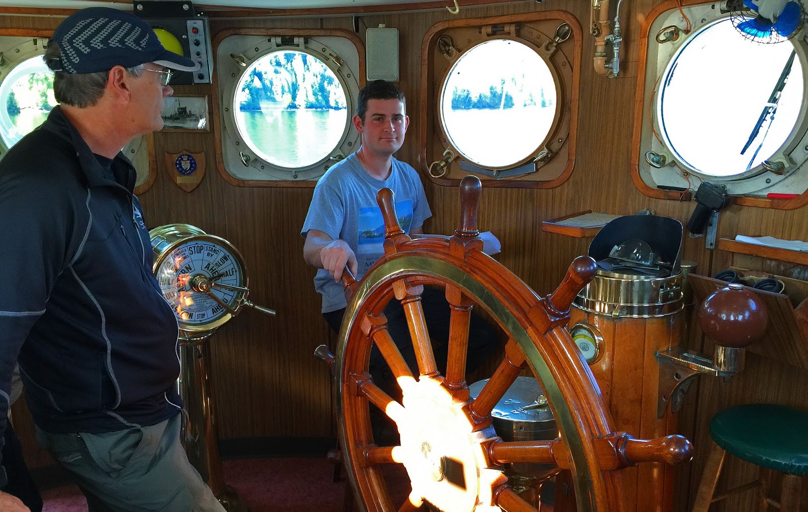
After breakfast we had lots of time to explore the ship which included visiting the wheelhouse and talking to Captain Spencer. When first seeing the Uchuck at the dock earlier in the morning one would think that this time honoured vessel would be captained by a bearded, almost senior veteran of many years on the high seas. I think many on board were surprised to find that Captain Spencer was a young man looking fresh out of college who you might think was just a deckhand. One thing for sure, the crew including Spencer work together very well and made all the passengers feel at home.

Who "looks" to fit the stereotype of a captain of a ship? Morley on the left or Spencer holding the wheel?

Our next stop was at the Kendrick Camp log sort located at the head of Kendrick Inlet. Not only was it an active log sort but the dock also was home to a fishing lodge and probably the source of the several fishing boats that passed us on the way up Tahsis Inlet.


How to get logs into the water. Stack them in a cradle like the one at the right of the picture. Wrap the stack with a couple loops of cable and then push the whole stack down the ramp to the waiting log tugs.


The floating logging camp crew house on the left and the fishing lodge on the right. If memory serves me right heavy duty tires were offloaded at this location.


After the Kendrick Camp cargo stop the Uchuck made it's way up Tahsis Inlet, through Tahsis Narrows, Hecate Channel and into Esperanza Inlet. After breakfast was served earlier in the morning Elaine went to work getting lunch ready which consisted of chili and made-to-order sandwiches which we enjoyed on the top deck.


Heading up Tahsis Inlet. Tahsis can be seen in the distance but we would be making a left turn soon into Tahsis Narrows.

The middle of September and look at the weather the west coast is treating us to! One last cargo stop to swap out garbage dumpsters. It was nice to see that garbage is handled properly in these remote camp and fish farm operations.

Our drop location at Rosa Island was coming up soon so we went to work suiting up and getting our kayaks ready for wet launching. One by one, two crew members easily picked up our fully loaded kayaks and moved them to the covered cargo hold and placed them onto a specially rigged pallet.

Kari loaded and ready to be hoisted overboard. This is what we came for .... to heck with the paddling!! LOL

I think every one of the tourist passengers were watching us from the wheelhouse viewing area. We had many discussions with them on the way out from Gold River and they seemed amazed that we were going to be disappearing in our trusty rides for the next 10 days. I checked the time (2:15pm) we launched and began our adventure in the Nuchatlitz.


Kari going over the side


Here's a short video of Gary's ride


Lynn followed by Morley and Robyn


And finally I'm hoisted overboard while the tourists watch.


No sooner than I was clear of the Uchuck she continued on her way towards Kyuquot.

Our original plan was to head west towards Catala Island Marine Park about 2nm in the distance and set up our first base camp. However with the conditions being so perfect and the long range forecast in our favor we decided to paddle southeast to Benson Point about 8nm's away instead. 

Lynn checking her chart as we make the decision to head to Benson Point

And so our paddling adventure in the Nuchatlitz begins here but it will continue on another blog post coming shortly. If you have any questions about the MV Uchuck III or Get West Adventure Cruises please comment or email them to me at geckopaddler@gmail.com.   


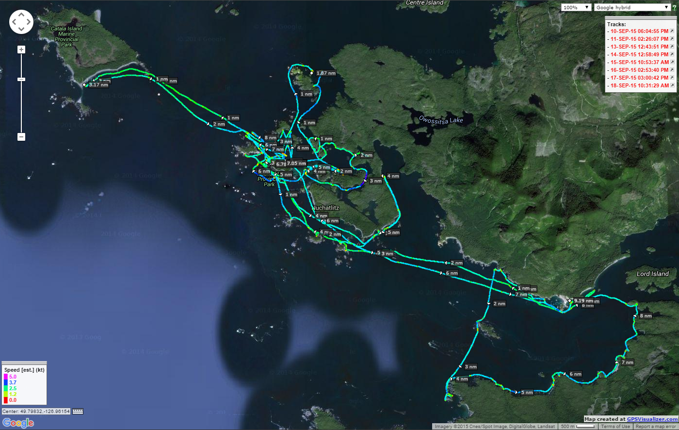
Our track from Gold River to Rosa Island on the Uchuck III

Saturday, November 28, 2015

Working Through The Hand Of God

A couple weeks back we headed out to the beach at Esquimalt Lagoon with Kari Challenger to work on a rescue that we all hope that we will never have to do for real. Kari is a paramedic in Vancouver and recently we have had many discussions about providing CPR while on the water and how to perform the Hand of God rescue. 

For those of you who might not know what the Hand of God is, it simply is rescuing an upside down kayaker who might be unconscious or simply is trapped inside the cockpit which I have seen happen a few times. Thankfully in both cases another paddler was close by and righted the paddler with the Hand of God rescue. Could you perform a Hand of God rescue if that happend?

Kari and I spent some time watching videos on the internet prior to attempting it for the first time and we talked through the steps that needed to happen for it to be successful. For our scenario we had Robyn close by for me to use a T-Rescue as an option instead of wet exiting my kayak if the Hand of God didn't work out. She also was able to video how Kari managed both attempts allowing for review later. Robyn and I video all of our training sessions when working on new techniques and even when refining some of the basics.

A few comments about what happened. On the first attempt Kari did a really good job in getting me upright in a continuous motion. On the second attempt you'll notice that my kayak gets caught on hers which prevented her from continuously rolling me. The difference was that on the second attempt her lower hand didn't stay on the cockpit combing pushing my kayak down and away from hers. She then had to resort to using a lot of muscle power to finish off the rescue. In both cases then end result was the same but the little technical things make so much difference.

At lot of you are probably heading to pool sessions over the winter. Why not try and figure out the Hand of God rescue?


2015 Paddle #41 - Rescue Training
Distance: 0 nm (0 km)
YTD: 256.15 nm (474.39 km) Needs editing once Nuchatlitz blogs are complete.

Saturday, November 21, 2015

Port Renfrew Playtime!!

Yeah I know .... I haven't blogged in a few months (shamelessly holding my head low). So a quick update on our adventures.

Our September Nuchatlitz trip tracks
Since our last post in August (really??) we went on a multi day trip to the Nuchatlitz in September with four other paddlers which was so amazing in every aspect that I will blog the adventure for you now that the rainy winter season is upon us.

I managed to get out on to the ocean once with Kari Challenger who was with us on the Nuchatlitz trip for a day of rescue refreshers while on a paddle to Rum Island. More about rescues with Kari in a future blog post :-)


Since then Robyn and I have been in the pool a couple of times working on things like the other side or if you prefer the offside roll. ;-) Surprisingly I figured it out during our first pool night which is cool so now I can spend the rest of the winter pool sessions refining it.

Other than that we haven't been on the water at all as our other life stuff (volunteering and work) has taken up a lot of our time. Refocusing our energy we have decided to step back from a few volunteer obligations and focus ourselves to a couple causes that are dear to our hearts. This will leave us time to do what we love best .... go play on the water!!!

A couple of weeks ago we managed to join up with Patti and Yves of Go Kayak who were camped out at the Pacheedaht Campground in Port Renfrew for a day of rock gardening. Shortly after arriving fellow paddlers Gene, Reale, Michel and Gerhardt joined the group to do some rough water play paddling.

Launching at the mouth of the Gordon River
The campground is situated right at the mouth of the Gordon River which makes for easy launching of our kayaks especially on this day when the surf was a gnarly mess of 5 foot cresting waves pounding the beach. Great conditions for the mass of surfers present but there was no way a kayak could launch from the main beach without basically getting the crap beaten out of you.


Lots of moving water today :-)
Our group paddled out of the river and explored the many sea arches, slots and other rock formations on the north side of the inlet on our way out towards Thrasher Cove. With no wind we only had to contend with big sets of swells arriving in a cycle of every 7th or 8th wave which challenged us every time we went into a play zone.


A BIG 'boomer' at Hammond Rocks

The wave energy was pretty amazing and it was the most we have experienced at Port Renfrew creating some interesting timing issues as I found out quickly a few times when the "big ones" exploded around me (us) while in the middle of a feature. A little unnerving at first but only a few close calls of nearly capsizing with some colorful language got me pretty stoked quickly. Ya!! I loved every minute of it!!

Here's a little video of our fun and it's "G" rated with the music replacing the odd &$#@(&%!!!


2015 Paddle #40 - Port Renfrew Rocks!!
Distance: 8.50 nm (15.74 km)
YTD: 256.15 nm (474.39 km) Needs editing once Nuchatlitz blogs are complete.