Showing posts with label Sucia Island. Show all posts

Monday, August 1, 2016

San Juan Expedition Part 3

Sucia Island Touring - Tuesday May 3th (Day #5)

We woke up to cloudy skies after a few showers during the night. After breakfast Robyn, Kari and I decided that we would spend the day hiking around the island looking for some of the geocaches on the island. Michael and Lynn decided that they would circumnavigate the island by kayak and hopefully we would see them while we were hiking.

It's hard to imagine that this jewel of an island only cost $25,000 back in 1960.

Sucia Island has over 10 miles of hiking trails weaving along the shoreline or through the forest that covers most of the island. Like we do on most of our trips, Robyn uses her GPS to find any geocaches that might be in the area so we decided to head towards Ewing Cove locating several caches along the way with the last one giving us a view of the Cluster Islands. One of the great things about Sucia Island is that it has over 60 campsites spread out through the 564-acre marine park and we soon found out that we were the only ones actually camping on the island during our stay.

A view of the two privately owned Finger Islands and Matia Island
3 miles in the distance from the Echo Bay campsites

Walking along the shoreline trail high above the water near Wiggins Reef we spotted Michael and Lynn paddling into Echo Bay. From our vantage point we could see Matia and Clark Islands and all the way down to Lawrence Point several miles away.

We spotted Lynn and Michael while hiking to Ewing Cove

We came across several of the Washington State Parks composting outhouses that I consider to be 5 star in terms of camping amenities and the one at Ewing Cove just might have been my favorite on the whole trip.

I never thought outhouses would be so attractive to visit and look at.

Not the usual thing that one finds in a geocache. LOL

Our return route was via Shallow Bay which was home for many of the Chinese workers who were illegally imported as laborers in the late 1800’s and early 1900’s. Contrary to the name, the Chinese hid in the forest and not in the China Caves that can be found at Shallow Bay.

Shallow bay offers a big sandy crescent moon beach with several campsites

The China Caves that weren't actually used by Chinese workers to hide in. Still, pretty cool to see.

Returning back to camp I spent some time setting up my hammock for a much needed nap and then went to work rigging up a shower area in a vacant campsite nearby.

I rigged a tarp to provide privacy in our shower area near the edge of a cliff in the site next to us.

We noticed a large group of people walking up the trail from the Echo Bay marina and they turned out to be part of a Sucia Island tour from Orcas Island. As we watched them look around Fossil Bay we noticed a couple with Geocaching patches on their packs and talked with them for a bit. They told us that on the way to the island they spotted a pod of orca not far from shore close to our location and as luck would have it, we were out hiking during that time.

Lots of fossil on the cliff side near our campsite.


We spent the rest of the day checking out the fossils on the cliff near the camp or just lounging around camp as Kari spotted what looked to be very large sandpipers with long curved beaks on the beach below us. Checking my bird book, we figured out that they were migrating Whimbrels which we had never seen before. After dinner we sat around the campfire and checked the 9:30pm forecast only to be surprised by a building NW 20+ knot wind forecast that was supposed to happen during the middle of the night.


Waiting for Patos Island - Wednesday May 4th (Day #6)

Right on schedule just around midnight the NW 20 knot winds came up fast and started rattling our little camp. After having very little wind at all on the trip it was a bit annoying trying to sleep while our tarps and tents took the brunt of the gusts that came through our little tombolo campsite.

When we finally woke up in the morning the skies were overcast with a little drizzle and the winds were continuing to blow pretty good. Listening to the extended forecast it looked like we might see the winds start to diminish later in the day and we decided that might be our opportunity to head towards Patos Island only 3 miles north of us.

Riding out the drizzle Kari's does some reading and I work on a taut knot that Michael showed me.


In the meantime, we suited up in our rain gear and all went for a little hike to EV Henry Point to locate a geocache and get some great views of the area from high up on the cliffs above the fossil beds.

Michael, Robyn, Kari and Lynn

Great view from EV Henry Point. Saturna Island way in the distance and our little campsiteon the
tombolo under the trees. From this location wecould see how the current was interacting with the
NW winds.

We had no idea what the heck this trail marker meant other than maybe "You are here" LOL

Returning to camp we made lunch and decided to head out on another hike to Johnston Point but half way there the sun started to come out and the winds slowly started to reside. We had a little group discussion and decided to head back to camp to pack up and wait for an opportunity to head to Patos Island.

Launching towards the sunset for Patos Island.
We had a window of opportunity to make a run for the island and off we went.

Just after 5pm we took to the water and paddled in choppy conditions due to the wind and current working against us but we managed to land on Patos Island at around 7pm.
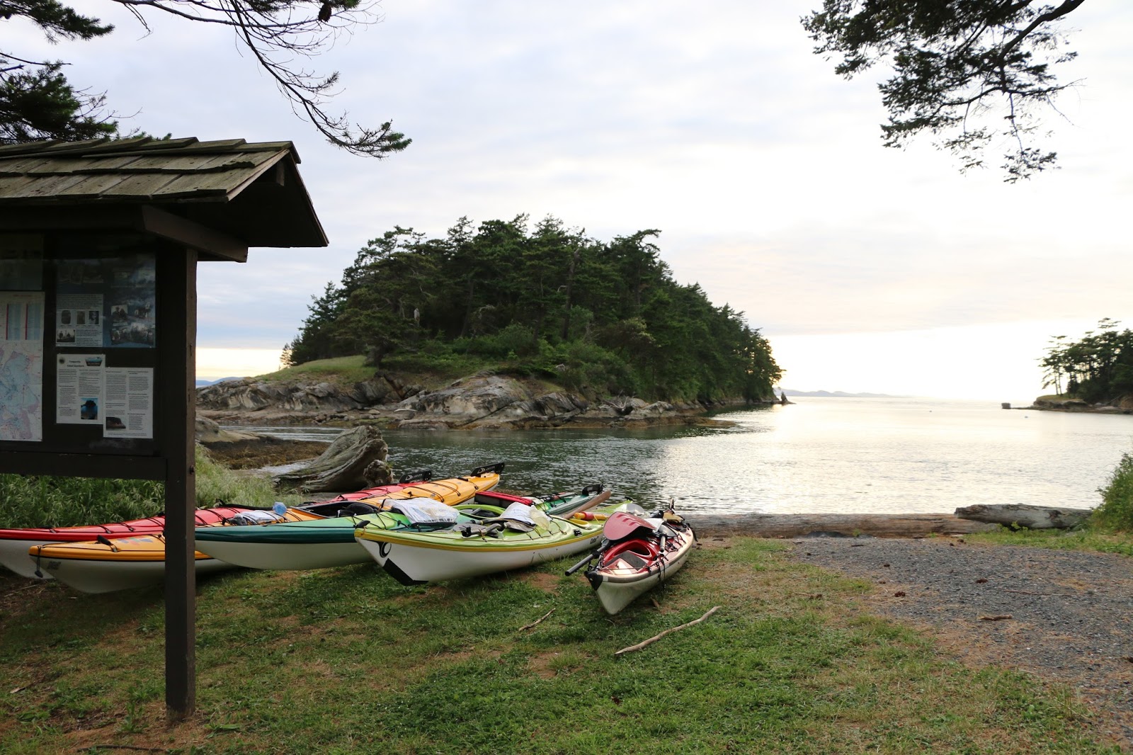
Our kayaks tied up for the night near the campsite kiosk

The main camping area that is exposed to the elements.

The camping area was on a nice little point that offers views of Sucia Island to the south and Saturna Island to the north but we found a site protected from the wind in the trees.

What might be home for the next couple of days. Nice and cozy if the winds keep howling.

The winds continued to decrease a bit and we were blessed with one of the most amazing sunsets that I have ever seen as we sat around a campfire on the point to watch the sun go down. Just before heading to bed we checked the forecast for the next day and it wasn’t looking good with the NW winds stating to blow again overnight. It was beginning to look like we might be staying on Patos Island for a couple of days.


2016 Paddle #21 - Sucia Island to Patos Island
Distance: 3.09 nm (5.72 km)
Trip: 53.03 nm (98.21 km)
YTD: 198.92 nm (368.40 km)

Note: More pictures of the entire San Juan Islands trip can be found by following the link HERE

Saturday, July 9, 2016

San Juan Expedition Part 2

Turning the Corner (Blind Island to Clark Island) - Sunday May 1st (Day #3)

After a fitful sleep on Blind Island due to our site not being level we woke up to another day of sunshine and no winds. Our plan was to be on the water by no later than 9:00am and head east through Harney Channel towards Obstruction Pass 4nm in the distance. We really didn’t have a particular camping destination planned for today but knew that there were a couple of sites to check out before we would turn the corner at Lawrence Point towards Clark, Matia, Sucia and Petos Islands.

Leaving Blind Island only the Washington State Ferries were on the water with us this morning.

Lynn and Michael as a ferry leaves Orcas Island

Other than several Washington State ferries crossing between the islands there wasn’t any marine traffic to speak about as we crossed East Sound and located the state recreation site just before Obstruction Pass. Feeling pretty good about ourselves Michael and I got into a rendition of the theme from Gilligan’s Island and the wreck of the S.S. Minnow just as we about to land at the state park. Sure enough I ran up onto a rock and heard an unfavorable cracking sound somewhere below the waterline of my kayak. Karma?? 

The beach at Obstruction Pass park

After the rest of group landed I rolled over my fully loaded kayak for a quick inspection and thankfully saw no signs of damage. I came to the conclusion that it probably was a few barnacles that I crunched while running aground. In any case I would do a proper inspection at our next camp location hoping that my front hatch wouldn’t be taking water on.

The Obstruction Pass park is situated high above the water on a bluff with campsites nicely spaced offering views of Lopez Island and the Olympic Mountains in the distance. If it wasn’t for San Juan Island blocking our view, we would have been able to see Victoria only about 18nm SW from this location.

Great view of the Olympic Mountains in the distance.

Since it was still early in the day we decided to take advantage of the last of the slack and make our way through Obstruction Pass towards the next possible campsite located on Doe Island about 3nm NE of us. While paddling through the pass, which was starting to show the beginning of an ebb flowing against us, we came across several NDK kayaks playing in the rock gardens and sure enough we discovered they were part of a group from Body Boat and Blade, Eastsound, Orcas Island.

Leaving Obstruction Pass we spotted a few tankers in Rosario Strait as we were carried on a back eddy towards a campsite situated in Doe Bay. The Doe Island State Park has limited landing areas due to the steepness of the island but does have a few primitive campsites facing south east. We decided to make this our lunch stop and press on towards Clark Island to make camp for the night.

Lunch stop on Doe Island

As we approached Lawrence Point we noticed that the water was very confused as a number of power boats were coming close to the headland churning up the water. Rounding the point, we were a little surprised to feel a very brisk NW headland wind which, combined with current, created a bit of a rip tide. A couple of sea lions seemed to enjoy playing in the waves as they swam around and under us as we tried to punch through the confused water. For several minutes we made absolutely no head way at all and the thought crossed my mind a few times that we might just have to head back to Doe Island for the night. Once we moved away from the point we slowly started making progress towards Clark Island but it was a slog to say the least taking over two hours to make the 2nm transit from Lawrence Point. It was a long day on the water as we finally landed at the campground a few minutes before 4:00pm and went to work setting up camp on the smooth gravel beach facing east.

That evening we decided we would head towards Matia Island in the morning but would give ourselves a later start as the forecast was favorable and we could take advantage of the currents. From our campsite on Clark the view of Mt. Baker was spectacular but there was a constant drone of noise coming from what we thought was the Cherry Point refinery on the mainland USA.  As the sun set we watched the Seattle to Alaska ferry heading north and then a huge oil tanker heading south towards Rosario Strait.  Oh, yeah ... the outhouse is typical of many of the Washington State Parks we visited. Pretty nice huh?

Clark Island camp on the beach

Our view from the beach of Mt. Baker at sunset ... stunning!!


2016 Paddle #19 - Blind Bay Island to Clark Island
Distance: 14.59 nm (27.02 km)
Trip: 40.54 nm (75.08 km)
YTD: 145.89 nm (270.18km)


Emerald of the San Juan's (Clark Island to Sucia Island) - Monday May 2nd. (Day #4)

We woke up to brilliant sunshine and no wind and the ever present constant drone from Cherry Point. Since we were waiting for the slack time, Michael headed out to explore the island a bit while Robyn, Kari and I went searching for a couple of geocaches and the group sites that were supposed to be around here somewhere. As we were zeroing in on our first cache we came across the group sites located at the southern tip of the island nestled in the forest with views southeast towards Lawrence Point. 

Good morning from Clark Island

And yes we even found some geocaches on the trip. Kayaking Kare Bear and RVTraveller

Just after 10:00am we were on the water heading towards Matia Island in absolute glassy conditions. We managed to spot a few porpoises along the way and a number of sea birds such as rhinoceros auklets, guillemots and gulls. Receiving a gentle flood push we completed the 4.5nm transit to Puffin Island just off the south end of Matia in less than 2 hours but sadly didn’t see any puffins at this time of year.

Perfect conditions heading towards Puffin and Matia Islands

Michael checking the rocky slopes of Puffin Island.

The terrain of both Puffin and Matia Island was very steep making landing virtually impossible except for Rolfe Cove on Matia where the campsite is located. We decided to check out the campsite which faces NW and found that even by noon it was just starting to receive sunlight on the beach. The campsite itself is nestled just above the beach in the forest but we felt that we would be better off heading towards Sucia Island only 1.5nm in the distance rather than spending a night here.

Looking like several islands, Sucia Island consists of many fingers of land and a few smaller islands.

Paddling towards Sucia from the SE you realize how expansive the island is with its many bays, finger islands and noted 10 miles of hiking trails. As we approached the island we decided to head along the west side of the island towards the Shallow Bay campsites but as we got closer to Fox Cove we could see a campsite situated on a grassy tombolo. We paddled into Fox Cove which is protected from the open water and after checking out the campsites there decided that this would be our home for the next couple of nights. It didn’t take long for us to discover that Sucia was indeed the emerald of the San Juan’s with over 60 mooring buoys, dock facilities for pleasure craft, over 60 campsites situated all over the island and several fossil beds which we explored. 

The Fox Cove campsite on the tombolo just ahead and nobody was there!

Paddling into Fox Cove

We set up camp in a site that had to be at least 75’ x 75’ and at bargain price of only $12 for all 5 of us. As the day progressed we checked the forecast and although it was sunny it was calling for possible thunder showers later in the evening so just as a precaution we set up our tarps in the warm sunshine. Later in the evening the clear skies started to give way to clouds rolling in from the west and it wasn’t long before we heard the rumblings of thunder somewhere in the Cascade foothills as we sat around the campfire. Just before bedtime that we felt the first raindrops. There’s something magical about listening to rain falling while you're bundled up in your tent.


Yup ... all this for $12 per night for up to 8 people.

Collecting driftwood for our fire later in the evening.

The clouds start to arrive as the sun starts to set.

Who brought the marshmallows?? 


2016 Paddle #20 - Clark Island to Sucia Island
Distance: 9.40 nm (17.40 km)
Trip: 49.94 nm (92.48 km)
YTD: 195.83 nm (362.67km)

Note: More pictures of the entire San Juan Islands trip can be found by following the link HERE