Sunday, August 23, 2015

God's Pocket - 7 Days plus 1 (Part 4)

Day 5 - Wednesday July 15, 2015

Drip, drip, drip ..... the first sound of the morning as we woke up to rain and climbing out of the tent our camp was surrounded by fog as well. We had planned on heading towards Loquillilla Cove for the day but the weather was telling us otherwise. Making breakfast we listened to the latest weather report on the VHF radio and there was good and bad coming. The good was that it was going to be clearing as a high pressure ridge was going to slide down from Haida Gwaii. The bad was that it was going to get windy on Friday and Saturday .... really windy to the tune of 20 - 40 knots from the NW late each day.

Just as we were finishing breakfast the rain stopped and the fog started to lift teasing us with blue sky and whispering clouds. Time to load up the kayaks and continue with our plans to head up Goletas Channel and follow the shoreline of Nigei Island to Loquillilla Cove. 

A change in the weather is coming as we set out on our quest for a small creek located at Loquillilla Cove.


Lately I have been thinking about Alaska and I remember saying to Robyn that it is just up there :-)

I paddled off shore to capture this image of our
kayaks dwarfed by the cliff face.
Unlike the shorelines that we have paddled on this trip thus far, the south end of Nigei Island is a perfect example of the geographic diversity at the northern end of Vancouver Island.

Massive cliffs with exposed sea caves greeted us at low tide as we headed west to our destination. We did a little bit of exploring on the way there but wanted to take advantage of the remaining ebb to carry us along. There would be plenty of time on the way back to explore but first we wanted to make sure that we reached Loquillilla Cove to find the water source to fill up our dromedary's and most importantly, my shower bag!

Just before entering Loquillilla Cove, Gary and Jane spotted a humpback whale that surfaced just behind Robyn and I and it kept our streak of daily humpback whale sightings intact.


Stan and Jane enjoying lunch while the others are exploring.
Loquillilla Cove is a wonderful place to visit and it would also make a great camping destination. Sheltered from the prevailing NW winds it has a very large crescent moon beach of fine pebbles with a small creek located at the NE corner.


As the group started lunch I decided to set my crab trap. So far on this trip I haven't had much success trying to catch the elusive crustaceans but I thought that maybe this cove might be the perfect location.

The view looking at Vancouver Island in the distance. A pretty location to visit if you are in the area.


"Gary .... there's the perfect place for a skinny dip" :-)
After lunch we went on the search for water and although the creek does babble into the cove we needed to hike into the forest a bit until we found some deeper pools that would make filling our water containers easier.

Gray and Jane had other plans like having a good wash with fresh water.


Cool, clear water ... water... water
Nice clean flowing water to fill my shower bag. It was going to be worth hauling the 20 liters back to camp and all I could think about was the nice warm shower that I would have the next day.

Arriving back on the beach our friends from Vancouver had just arrived from their trip to Vansittart Island. They too had listened to the weather report and decided to "bug out" rather than running the risk of being weathered in up there. Chris told us they saw breaching humpback whales as well as orca and lots of sea otters.  Robyn ... we have to go there next time!!

It was time for us to head back onto the water and just in time as the winds started to pick up considerably. But first I had to check on my crab trap. Once again ..... nothin!! Maybe they just don't exist in these clean natural conditions??


Up to this point on the trip we had been blessed with sightings of so many different species of wildlife but one in particular hadn't been spotted. I'm talking about the adorable sea otter that we have seen on the west coast of the island. Paddling back towards camp we noticed something ahead of us frolicking on the surface and it could only be one thing. Our first (and only) sea otter! 

'Whatcha doin out here all by yourself buddy?'

The increasing wind made the our paddle back to camp a little sloppy but thankfully it was coming from behind us and with the flood direction. The paddle up to Loquillilla Cove took 2 hours but the return trip only took 1.25 hours in comparison. My appreciation of how the water and wind interact with each other at the north end of the island increased on this trip. Although God's Pocket is only a stone's throw away from Port Hardy, using the currents and wind to your advantage is key to paddling in the area.

Just after arriving back at camp 3 ladies arrived and set up camp at the alternate kitchen location. Talking with them later they told us that they were from the Sunshine Coast (Gibson's) and were planning on doing a little touring much like we had done the past few days. Hmmm .... the forecast might have a say in that.

Lazing around camp the rest of the afternoon I set up my shower using our bear cache pulley system and couldn't wait for the next day when it was warm. It was a little cool especially with the wind starting to blow but it sure beat the salt water sponge baths that I had been relying on so far.

The little bonsai tree across from our camp. 

Chris and his group arrived back at Nolan Point and after a discussion with them they decided to head to Bell Island for the night. They were concerned with the wind forecast for the next couple of days and wanted to get closer to Port Hardy just in case.


The Vancouver group heads to Bell Island

A couple of nights ago I woke up to a lot of blowing and trashing in the water and now I put 2 and 2 together as a very large pod of orca made it's way past Jerome Island. What I had heard was orca in the middle of the night coming very close to our camp. I should have got up and checked it out huh?

This pod was made up of at least 20 individuals and they were heading towards Christie Passage following the eddy line where we have seen the humpback feeding the last few days. There was lots of tail slapping, spy hopping and I'm pretty sure we even spotted a very very young baby in the pod. Very cool!!!


A pretty amazing day. You can even call it a trifecta with humpback, sea otter and orca's being seen the same day!!!


2015 Paddle #27 - Loquillilla Cove Water Run
Distance: 11.90 nm (22.03 km)
YTD: 231.53 nm (‪428.79 km)


Day 6 - Thursday July 16, 2015

Our last day before heading back to civilization and since there wasn't a group paddle planned, Robyn and I decided to hike along the shoreline at low tide to the end of Nolan Point. The high pressure system was establishing itself on the north coast and it provided beautiful clear skies with a gentle breeze to start the day.

The view from Nolan Point, Jerome Island on the left, Lucan Islands at center and our campsite on the point on the right.

From the same location behind us looking east are the Noble Islets and Duncan Island with Vancouver Island on the right.


The east side of Nolan Point is a catch basin for driftwood and we soon discovered other man-made items that have made their way to the shores of BC.

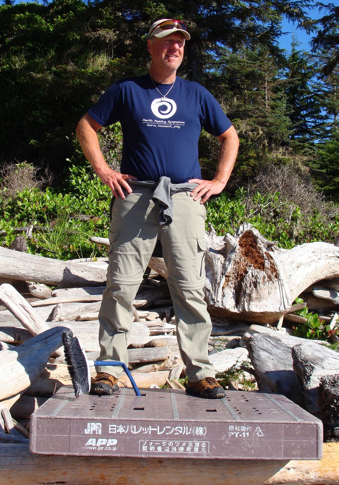
There have been a lot of reports of debris from the 2011 Japan tsunami on the west coast of Vancouver Island and it only makes sense that some items will or have made their way to the east coast of the island.

We found the usual suspects of fishing floats, Crocs, a few plastic water bottles and then I came across this pallet that I believe has Japanese writing on it. Did it come from the tsunami? Who knows but with the massive debris field that is circulating in the Pacific Ocean I'm sure we will come across more and more items in the future.


On our way back to camp we spotted Gary and Jane heading out to explore the under water life at low tide.

And Stan and Paula were also exploring the shoreline taking in the spectacular views.


After lunch Robyn and I headed out to once again try to catch a salmon. It would have made the perfect final dinner for the group but we had no luck other than catching several rockfish that were only bite size and not worth keeping.


I made Robyn a hand-line for the trip and she managed to catch a few rock fish on it so we know the rig works well. I can't wait to see when she hooks a larger fish like a 5-10 pound salmon. That should be fun!


Robyn's first catch on her hand-line. Pan size and perfect for two but not a big enough meal for the group. This one went back.


Back at camp the predicted afternoon NW winds started to increase and we checked the updated weather report on the VHF radio. It looked like we would have a window of opportunity to "bug out" of camp early the next morning when the winds would be light so we made plans to be on the water just after 7:00 am. Keeping the humpback whale sighting string intact, we spotted one on the backside of Jerome Island as it was feeding along with sea gulls and many of the eagles that we have seen the last several days.

Gary and Jane made dinner consisting of spaghetti bolognese followed by apple crumble for dessert and then we went to work disassembling the kitchen and loading the kayaks of non essential items to assist us in expediting our departure in the morning.

The feeding frenzy for sea gulls, eagles and a humpback whale.


Day 7 - Friday July 17, 2015

Robyn and I were awake just before 6:00 am and I checked the forecast which was calling for 10-15 NW for the next few hours before rising to 25-30 early in the afternoon. It was time to get moving so after a quick breakfast we moved the partially loaded kayaks closer to the waterline using Gary's hauling straps.

Time to load up .... the wind is starting to pick up and there are white caps showing beyond Jerome Island

Fully loaded and ready to go we watched as the wind against current started to change the sea state considerably and as a group, we made the decision to stand down. We wouldn't be leaving today unless the winds miraculously dropped.

We watched the waves build while the kayaks were packed and ready to go. 

Once the decision was made that we wouldn't be leaving God's Pocket, we hauled the fully loaded kayaks back up the beach using Gary's straps. (Thank you Gary for bringing the straps!!!)  With the six of us, moving the kayaks was relatively easy and it saved the task of unpacking everything to get the kayaks up to the headland.


Packed and ready. Now we just have to hang around and wait.

Jane passed the time napping :-)

Hey! We have hammocks ... perfect napping devices.

Later in the day I spent some time trying to balance rocks in the 25-30 knot winds. Talk about a challenge! Many only lasted minutes but a few managed to hang around long enough to get a camera for some pictures.


It was pretty obvious from the afternoon weather report that we wouldn't be leaving today so we set up our tents and went to work on planning dinner. Robyn and I had brought a 3 day supply for 2 of dehydrated meals consisting of pulled pork, black beans and rice which meant that we could feed the group tonight.


Big winds in the afternoon meant we would need another plan for the next day.

After dinner the group decided that we would get up at 3:00 am the following day which would allow us to be on the water at first light (4:30 am) which also was the slack water time. The wind was predicted to be 5-15 from the NW so with the slack tide we might be able to arrive back in Port Hardy for breakfast at Captain Hardy's by 8:00 am! LOL


Day 7 +1 - Saturday July 18, 2015

3:00 am, dark and the wind is still blowing. I scrambled out of the tent with my headlamp and met Stan and Paula heading into camp. After a brief discussion it was pretty obvious that we weren't going anywhere fast so it was back to bed.

6:00 am and I woke up to .... very little wind!! I scrambled out of the tent with my VHF radio and binoculars and walked to the viewpoint at the end of our campsite. The wind forecast was now 10-15 NW increasing later this morning and from what I could see beyond the eddy line which was now showing the effects of winds against current, the water was showing only the occasional breaking wave.

The past couple of years Robyn and I have worked hard to develop not only our paddling skills but we have also developed what we think are pretty good leadership skills for situations like this. It was time to put them to work so we woke the rest of the group and explained to them that we had a window of opportunity to attempt crossing Goletas Channel back to Vancouver Island.

We could sense a little bit of apprehension but part of our plan was to first get on the water and then paddle out to the eddy line just beyond Jerome Island to get a better look. Launching just after 7:00 am the low marine cloud was obscuring our view of Vancouver Island but we could see enough of the shoreline 1.5 nm in the distance. The wind was estimated to about 5-10 NW and the sea state was averaging a 2-3 foot chop with occasional breaks from some of the larger sets. Plotting a course of 180 degrees our goal would be to paddle across the channel to small beach which on our charts indicated a possible water source. I estimated that if we were to paddle at a moderate pace we should be able to reach the other side of the channel in about 30 minutes.

Consulting with the rest of the group as to how they felt about attempting the crossing we received a "Go" so Robyn and I took positions on either side of the rest of the group and we headed out into the channel. Paddling along in close proximity the group did an amazing job and I noticed how silent everyone was which tends to naturally happen when the conditions become a bit of a concern.

Lumpy conditions but the group presses on across Goletas Channel

Time flew by quickly as I mentioned to the group that we were now more than half way across and I could see the eyes of a black bear on the beach ahead. Of course there wasn't a black bear on the beach and if there was we certainly wouldn't have been able to see it's eyes but it got the group talking making fun of the nonexistent bear on the beach.

The next thing we knew we were out of the main flow of the channel and we entered the small cove of the beach which also provided shelter from the wind. The crossing took only 35 minutes which meant we were paddling at a pretty good pace of about 3 knots in conditions that were a bit of a challenge. An awesome job done by everyone and I think we all felt a sense of relief now that we had reached Vancouver Island, and no, there's weren't any black bears to greet us!

Stan and Paula complete the crossing into calmer water.


Sure enough, the little beach had a water source which was a waterfall a bit further back in the forest.

Now that we had crossed Goletas Channel all we had to do is put in a few miles of paddling to reach Port Hardy. In the case of the condition's deteriorating we had a number of locations we could stop if need be and the first one was Songhees Creek 2.5 nm east of our location. Although the main current flow was ebbing to the west we experienced a back eddy flowing our direction so we essentially were being pulled along towards Port Hardy in wind with current conditions. Nice!!


Landing at Songhees Creek for a rest stop.

A large expansive area that has good camping opportunities if weathered in.

Landing at Songhees Creek we were greeted by a paddler from Bellingham who with his group were attempting to paddle around Cape Scott. They had launched out of Port Hardy the day before and had run into the high winds as they entered Goletas Channel. They had spent the night on Duval Island before heading to Songhees Creek battling the back eddy that we had arrived on.

After launching from Songhees Creek we hugged the shoreline and made our way to Duval Island before entering the confined waters of Port Hardy Bay just in time for the winds to increase from behind us. The water out beyond Duval Point gradually turned dark with breaking whitecaps just as predicted. It looks like our group made the right decision to leave when we had the opportunity.

Port Hardy in the distance, wind and current with us and nothing but beautiful sunshine to greet us.

It was a great 7 + 1 days of exploring God's Pocket with Stan & Paula Ball, Jane & Gary Jacek and of course my honey Robyn. Now it's time to start planning for our next adventure on the west coast in September.

Loaded up and ready for the long drive home. 


2015 Paddle #28 - The Journey Home
Distance: 10.66 nm (19.74 km)
YTD: 242.19 nm (‪448.53 km)

Wednesday, August 5, 2015

God's Pocket - 7 Days plus 1 (Part 3)

Day 3 - Monday July 13, 2015

The easy way to wash breakfast dishes.
We up at around 7:00am and just as we started breakfast it started to pour so we went about the business of storing runoff water for use later. :-) Before retiring for bed last night we had a visit from the leader (Chris) of the Vancouver group located on the point. He wanted to check with us about making a run for Vansittart Island located at the north end of Nigei Island this morning. After confirming tides and the weather forecast with us their group decided that they would be vacating the primary site by noon and since it was raining we decided that we would spend the day relocating camp and just relaxing.

Since we had a couple of hours before moving, Robyn and I decided that maybe we could hike through the forest towards the eagles that we saw the previous day in Christie Passage. Outfitted in our Misty River raingear and rubber/neoprene boots we had a fairly easy trek the first several hundred feet until the undergrowth became too dense to make any headway without bushwacking.

We decided to head back towards camp taking our time to explore the forest while being protected from the rain by the canopy of the trees. Although we could hear the rain, very little made it's way to the forest floor other than the large droplets that fell from the canopy boughs high above us.

Most of the forest is now second or third growth but we did find evidence of some of the old growth trees that once would have covered the island.

Harvested many years ago, a stump of a very large cedar looks out of place.


relatively fresh wolf footprint. 
The island is known to have a small population of coastal wolves which we found evidence of at camp in the form of very old scat. While on our hike we came across fairly fresh wolf tracks in the mud around the headwater of the creek that runs past our camp.

I always wonder when hiking through a known wolf habitat if they are keeping watch on us. Once again it would have been a very special moment if we had come across one of these amazing animals in the forest. No such luck today. ;-(

We did however find possible evidence of a den in the bottom of a hollow stump. Something had definitely cleared all the moss and plant life away and the dirt was dry and semi compact.


Fungus and abalone shell
This forest did have treasures that we found like the fungus in this picture. Glistening from the rain drops that had made it to the ground there was also another treasure close by.

Sitting on top of the same log was an abalone shell that was firmly secured in place by the moss that it was lying on. In fact all throughout the forest we found many abalone shells that were always on a log and never on the ground.


An abalone shell located in the forest.

After seeing all the eagles in the area all I could think of was maybe they harvested the abalone and dropped them from their perches high above and then flew down to the forest floor to finish their catch.


And then we came across this solitary giant in the forest. Why was it still here after all these years? If it only could tell the tale of the history of logging on the island and why it was spared. Although alone, it was great to see it standing as a reminder of the old growth that once covered these islands.

Things grow big out here and some are centuries old.

Arriving back in camp, Chris and his group were just departing for Vansittart Island as the rain was easing up a bit. It was now time to go to work and relocate our camp to the point.

The Vancouver group leaves camp. We would see them again in a few days.

After a little bit of planning at the point campsite we set up tarps where our tents would be relocated to, moved our kitchen gear under those tarps, did a little bit more kitchen tarpology and moved the dry kitchen gear under it.

Our 12' x 15' tarp worked great to cover the kitchen area.


Carabiners come in handy when doing tarpology. Quick and easy to set up. 
Then it was time to move the fully assembled tents across the dry creek bed, through the trees and to our tarps. By the way, we did this with the mats and sleeping bags still inside the tent and any other lightweight items we decided could go along for the ride. Everything worked like a charm and made it's way to the new site nice and dry. Planning is everything!!


Gary and Jane arrive at the new camp with their tent after a challenging traverse through the trees. Thankfully what they thought might have been a retractable tent pole breaking was only the snap of an eyelet letting go from the pole attachment point.

This way, no this way, no this way, no this way ..... :-) LOL

Robyn's ... this one went back.
Robyn (using a hand line) and I decided to do some fishing around the Lucan Islands in the afternoon but we had no luck other than small rock fish that we both released. A small powered aluminum boat arrived  unexpectedly with a couple of fishermen right next to me. They casted their pink buzz bombs and caught a salmon on the first cast and promptly left leaving us feeling quite dejected. :-(  We did however see a humpback whale feeding in the same eddy line as yesterday so that lifted our spirits a bit.


Back at camp Gary and Jane served up smoked salmon and cheese followed by lamb orzo and feta. With all the rain we had the past 24 hours the mosquitos were hungry too and we were the perfect food bank for them. Pass the bug spray please!!!

Dinner, bug spray and relaxation was on the agenda for the evening.

The clouds started to part and we got our first glimpse of the sun since we arrived. It was a welcome sight and the forecast was for a building high which would clear out the clouds but it also meant that we were to expect the winds to pick up later in the week. But for now, we took in our first sunset in God's Pocket ....... spectacular!!!


Stan and Paula reading in a tranquil setting

Sunset in God's Pocket 


Day 4 - Tuesday July 14, 2015 

What was that? In the middle of the night I heard something thrashing around in the water very close to camp as well as a lot of blowing sounds which I thought might have been a sea lion. Trying to make sense of it, I thought it could only be a very, very large group of sea lions but until now we had only seen one occasionally. Oh well, back to sleep.

The glow in the tent could only mean one thing ..... no rain to wake up to and brilliant clear blue skies with not a breath of wind. The plan for the day was to paddle to the Bell Island campsite and circumnavigate Hurst Island. Finally, the perfect touring conditions!

You can see the high water line behind Robyn, Paula and Stan. Almost 15 feet difference between high and lows this week.


Gary and Jane .... loving the great day!

Leaving the shelter bay of our camp we headed out past Jerome Island and the view east towards Bell Island was stunning. We could see the two small islets (Noble Islets) right of center in the picture below, Duncan Island in behind, and beyond that, Miles Cone rising 139 meters above sea level on Doyle Island in the Gordon Group 6 miles in the distance.

We could see for mile and miles and miles.

Photo credit: Planetofbirds.com
Crossing Christie Passage we paddled through a flock (thousands) of rhinoceros auklets which is a close relative of puffins. Its name is derived from a horn-like extension of the beak and the horn is only present in breeding adults. From what Robyn and I could tell this was one big mating party as they all had horns!


Gary watching the rhinoceros auklets as we paddled through them slowly.

Everything grows big out here, even the shellfish. Check out these California Mussels!! They aren't bite size but meal size and no .... Robyn and I have never had one. What were we thinking???? 

We always carry the fixings for oysters but we have never harvested mussels. That has to change next time out!

I have mentioned about the great number of eagles that we have seen since arriving on the north coast of the Vancouver Island. Getting close enough by kayak while taking care not to frighten them and yet being able to capture imagines that do them justice was sure a challenge. The one below is of a juvenile bald eagle taken using our 6 year old Sony Cyber-shot with 8x zoom. It certainly is one of my favourite images from the trip.

A juvenile bald eagle stands guard outside of the God's Pocket Resort

Crossing Christie Passage we decided to check out God's Pocket Resort which is a favourite location for divers visiting the area. I can imagine what the view underwater must be like based on the diversity of the underwater marine life we had seen up to this point.

The very colorful God's Pocket Resort located only about 1 nm from our camp.

Continuing on along the south shoreline of Hurst Island we spotted Bell Island in the distance gradually being cloaked by fog. We were hoping that maybe the warm sun might burn off the fog but just in case Robyn had her GPS recording our track if we needed to retrace our way back to camp.

The fog completely covers the islands east of Bell Island

We entered the protected channel that lead us to the campsite on Bell Island. This site would have been our first camp location in the event that we were unable to make it to Nolan Point due to weather conditions after leaving Port Hardy. The campsite is situated high above on top of a midden with a pretty view of the islands nearby.

Lunch stop on the shell beach below the campsite.

There is room for several tents although it would take a bit of work to haul your gear up to the camp area from the beach. Still, this is a site that I really liked and would stay at in the future. There is also a fish farm a short distance from this site but we couldn't hear any evidence of its operation while we were there.


Can you envision your tent perched at the top of this cliff? What a great viewpoint!


Look who we came across. It's the Pacific Paddling Symposium Travelling Mug


The view of Harlequin Bay from the campsite.
After our lunch stop on Bell Island we headed back to Hurst Island and explored Harlequin Bay, stopping at the campsite on the north side. This site is also located on top of a midden and although not as high as the one on Bell Island it is a fair bit smaller in terms of the number of tents that could be set up.


This fire ran underground through the root system ... scary!
There are other possible places to pitch tents in the forest just behind the campsite if needed and I found evidence of a fire that might have got out of control in the past couple of years.

This is a perfect example of the need to keep any campfires on the beach and if possible below the high waterline.


We left the protected waters of Harlequin Bay and headed north to complete our circumnavigation of Hurst Island. For the first time on this trip we were able to see beyond the islands of the Walker Group and get a view of the mainland coast of BC.

The clear weather provided great views today and started future trip opportunity thinking :-)

The effects of the water and weather on the north end of the islands presented us with nooks and crannies to explore. Some of the crevices that we could paddle into were almost 100 feet deep and their walls were covered with a curtain of west coast rainforest flora. We kept our eyes open for one of the wolves that Chris and his group spotted here the day before but we couldn't find them. It looks like this might be a bucket list item that we might not be able to cross off on this trip.


Not much swell allowed us to explore the crevices.

Paddling back into Christie Passage we spotted the Scarlett Point lighthouse in the distance as we were gently carried south with the flood currents towards Nolan Point. Robyn and I were busy taking photos straggling behind the others when a humpback whale surfaced just off our starboard side. From the direction it was travelling it must have swam under our fellow paddlers without them knowing!

Stan admires the Scarlett Point lighthouse

Reaching the eastern shoreline of Balaclava Island we were greeted by a large group of eagles closely keeping an eye on us. It was hard to know which way to look as another humpback surfaced close to the group on our port side and then disappeared under the surface. Robyn and I decided that we would come back to this location in the next couple of days to try capture more images of the eagles with the Canon SLR that Gary lent me for the trip.

Another image of a mature bald eagle taken with the Sony Cyber-shot


Rehydrated strawberries are perfect for this!
Arriving back at camp Robyn and I were on chef duty and we served up our version of chicken cacciatore followed by a pretty decent strawberry shortcake for dessert. So easy to make and it was really quiet in camp while everyone savoured this tasty treat.


After dinner Robyn and I explored a magical place that I discovered while having a salt water spa wash the day before. Not far from camp and on the way to the tip of Nolan Point there is a pretty little bay. On my previous visit here I wandered into the forest behind the logs and found something very special.

Robyn exploring one of the bays close to camp

A fellow paddler (Morley) who we have tripped with before, happens to be an archeologist and he had told me about some of the culturally modified trees that he has come across in his line of work. Entering the forest there were several dozen culturally modified trees all around us and for me it almost was like you could feel the spirits of those who once inhabited these islands. Seeing evidence that first nations peoples not only lived here but relied on the forest to sustain them was very special.


Culturally modified trees. A cut is made at the base and the bark is stripped off.

As the day was coming to an end we spotted another humpback whale from camp and soaked in the scenery before retiring for the night. A pretty spectacular day all around.

The little bonsai like tree just across from camp. At high tide it is completely surrounded by water.


2015 Paddle #26 - Bell to Hurst Island Circumnavigation
Distance: 12.26 nm (22.70 km)
YTD: 219.63 nm (‪406.74 km)

Sunday, August 2, 2015

Double Day - James Island & Butchart Gardens Fireworks by Robyn Byrne

Earlier this year Mark and I committed the August 1st long weekend to helping our friend Gary lead a SISKA paddle to see the Butchart Gardens fireworks so it was a stay-at-home weekend for a change. We decided to kick it off by doing a bit of fishing and crabbing yesterday morning.

Getting ready to launch off Lochside Drive with the Anacortes ferry arriving into Sidney BC

We loaded up the Delta's (as we'd be using them that evening at the fireworks .  .  .  comfort being key) and we headed out to Sidney. Our plan was to put the crab trap down in a bay at James Island where we know there is crab. The tide was pretty low so we had a bit of a trek to the water's edge but the weather was perfect. Sunshine, calm waters, currents all in our favour!

Our first Dungeness catch .... and release :-)
After reaching James Island we paddled along the shoreline until we reached our destination. Mark put down the crab trap while I did a bit of buzz bombing. Before too long I had a flounder on my line!  A wee little one mind you but it was still fun. In the meantime Mark pulled up a beautiful Dungeness crab. Well over legal size and a male too. A keeper!  Unfortunately it was missing a claw and that's the best part of the crab so we took a photo and threw him back.  On the next haul Mark got a really nice Red Rock so we kept him.


Almost big enough for a single meal .... this one went back too.

Lunch stop below the high water line on James Island

By this time we were ready for lunch so we rounded the corner of James Island and headed back down towards the spot where the nice beaches are. Mark put down the crab trap and we found a nice spot to stretch out on the sand, have a bite to eat and enjoy the panoramic view of Sidney, Mt. Baker and the islands.

Now ... don't you fall down! 
Mark also practiced some of his rock balancing techniques while we were there. After lunch we got back in the kayaks, paddled over to the crab trap, pulled it up and .  .  .  nothing. Not a good crabbing spot I guess. We made a mental note.

Back at our put-in spot we pulled the Red Rock crab out of the kayak and he looked so sad. All alone. Not much meat for the two of us, lots of work to cook him. What to do?  We threw him back!


2015 Paddle #29 - James Island Deadliest (or not) Catch
Distance: 5.87 nm (10.87 km)
YTD: 248.06 nm (‪459.40 km)


At home we had time for some dinner before heading to Brentwood Bay to meet up with the SISKA group for the fireworks paddle. We were the first to arrive so we unloaded and carried our kayaks and gear down to the almost non-existent beach (the tide was up). As there were 16 kayakers on this paddle I tied our two boats onto a tree limb to make more room on the non-existent  beach. LOL Before long everyone arrived for our 7:45pm beach talk and we affixed a glow stick to the back of everyone's kayak for use when the sun set.

A gaggle of SISKA paddlers head out towards the fireworks show

We had 2 never-kayaked-before paddlers with the group so Mark put his Level 1 Instructor knowledge to good use and got the paddles turned the right way around and up before we all headed out of the marina. Mark took the lead and I was the sweep. We toured through the harbour and into the Butchart Gardens dinghy dock bay, then down to the end of the inlet for a group photo. We weaved our way through the dozens of anchored motor boats and yachts that had secured their spots for the night.

A group selfie of 15 plus me equals 16 accounted for and safe.

Time to find a place to view the show amongst all the powered pleasure craft.

Great fireworks selfie
Out group found the little strip of beach available for fireworks viewing. Although others were already there we managed to find room for the 16 of us and we munched on some snacks while we waited for the 9:45pm show. Right on time the fireworks started and it was a great performance as usual.


Lots of big booms and massive star bursts as ususal. Never a disappointment. 

Following the fireworks we all got into our kayaks, turned on our headlamps, navigation lights, whatever we had, and grouped up. It was really dark now!  Tough to see all 16 of us plus there were other kayakers around that made it confusing. Once we determined we were all there Mark lead us all over to the far side of the inlet (where the power boats couldn't go) and we slowly made our way back to our launch site.  We carefully dodged buoys, docks, anchor lines and dinghies motoring by.

Suddenly, closely behind us where we'd just been, there was a huge collision! A power boat had hit something!  It was too dark for us to see but it sounded like he hit either a dock or another boat. There was much commotion, yelling and lights. Although we were very concerned this was not a place for kayakers to be in the dark so we carried on and left the on site SAR and police boats to sort it out. When we reached our put- in spot there were ambulances arriving at the docks. Turns out two power boats collided and 7 people were taken to hospital. Be careful out there people!

Our little group had a great time and the newbies were very pleased.  The fireworks are a must see by kayak. We look forward to this paddle every year.


2015 Paddle #30 - SISKA Butchart Gardens Fireworks Paddles
Distance: 3.56 nm (6.59 km)
YTD: 251.62 nm (466.00 km)